|
stuving
|
 |
« Reply #165 on: October 27, 2017, 10:43:36 » |
|
All our road authorities provide updated roads data to the official National Street Gazetteer, which is not published nor open data; you need to buy a license to use it. This is what the mapping and satnav providers have to use (I assume the major ones do), but as it's not public I can't say what detail it includes about (for example) whether you can do a U-turn and in which size of van.
When Wokingham station level crossing got its new traffic lights, a new one-way system was added as well. That meant new roads signs were needed for many of the town's junctions; not just because of newly-banned directions and turns, but also for high-sided vehicles avoiding the low bridges. Having noticed some of these new signs were wrong, I went round the town and found every newly changed sign was wrong in some way.
In most cases this was minor, down to not understanding the use of braces around road numbers, but a few had serious practical implications. I contacted the council, and was told they "might" review and revise them (nothing has happened since) but in one case they dashed out and put up new signs within a week. That was for new signs before the Market Square junction, where trucks avoiding the low bridge on the southbound A321 must turn right so they can cross the level crossing instead. Following the old signs, they would turn right just before the first low bridge (at the Carnival Pool) and then need to turn left at the crossing, a turn not not only now banned but geometrically impossible for an artic.
I tried to persuade them to look at the signs as someone using an out-of-date satnav, and add any destinations or road numbers that they would need. They reckoned that it would only take about six months for commercial drivers to get the changes, and not much longer for anyone else who was relying on one. I wasn't convinced.
You still see lots of drivers disobeying the signs and even the traffic lights - but they are locals who think the rules don't apply to them because it would be inconvenient if they did.
|
|
|
|
« Last Edit: February 01, 2018, 20:12:33 by stuving »
|
 Logged
|
|
|
|
|
LiskeardRich
|
|
« Reply #166 on: October 27, 2017, 11:05:44 » |
|
They reckoned that it would only take about six months for commercial drivers to get the changes 6 months for Regular visitors to town presumably to get the changes? One particular town on my patch I’ve only visited once in the last 6 months. It happens to be a town with very narrow streets and tight turns. They’re suggesting I should get the town by now? No chance! |
|
|
|
|
Logged
|
All posts are my own personal believes, opinions and understandings!
|
|
|
|
patch38
|
|
« Reply #167 on: October 27, 2017, 11:35:56 » |
|
All our road authorities provide updated roads data to the official National Street Gazetteer, which is not published nor open data; you need to buy a license to use it.
Stuving describes it well. The ever-useful Wikipedia says: The National Street Gazetteer is a public database that is kept private
If I could spell 'oxymoron', I'd look that up too  |
|
|
|
|
Logged
|
|
|
|
|
stuving
|
|
« Reply #168 on: October 27, 2017, 11:52:38 » |
|
All our road authorities provide updated roads data to the official National Street Gazetteer, which is not published nor open data; you need to buy a license to use it.
Stuving describes it well. The ever-useful Wikipedia says: The National Street Gazetteer is a public database that is kept private
If I could spell 'oxymoron', I'd look that up too I think that suggests something that is not and never was true. A great deal of material that was both public and published was previously only available if you paid for it; that's what HMSO was there to produce. OS▸ mapping for commercial use needs a paid-for license, and the NSG is the same. It may be reclassified as open data (as the Environment Agency's measurements were, for example) or it may not. Open data is usually justified* because the data are generated anyway for other purposes. OS does mapping as its mainstream activity, for which it charges. The LTAs▸ don't, but they need all the money they can find. And NSG (if it exists as a thing in itself) is like OS. Hence maybe. *PS: I mean within government, as a reason for actually doing it. There are broader arguments, "political" in both partisan and non-partisan senses, about the desirability of open data. |
|
|
|
« Last Edit: October 27, 2017, 22:12:54 by stuving »
|
Logged
|
|
|
|
TonyK
Global Moderator
Hero Member

Posts: 6438
The artist formerly known as Four Track, Now!

|
|
« Reply #169 on: October 27, 2017, 12:10:33 » |
|
My normally very reliable sat-nav has tried to take me into roads clearly not wide enough for a car and onto tram tracks in Nottingham. The onus is always on the driver to know the law regarding their vehicle, to read road signs and use the best driving aid available: i.e. the brain.
Mine is also usually reliable (sat-nav that is, not brain) apart from a few omisssions, usually new roads. But coming home from Devon to Bristol, it advises me to turn right from Parsonage Hill onto the A361. I estimate the drop from the bridge to be about 20 metres. |
|
|
|
|
Logged
|
Now, please!
|
|
|
|
rower40
|
|
« Reply #170 on: October 27, 2017, 13:08:07 » |
|
Stuving describes it well. The ever-useful Wikipedia says: The National Street Gazetteer is a public database that is kept private
If I could spell 'oxymoron', I'd look that up too Off-onna-tangent: cf. the difference between public and private schools! And between public schools here, and those in USAnia. "Our" public schools were so-named to differentiate them from schools run by guilds, which were only open to sons of guild members. Anyone could go to a public school, as long as the bills got paid. American Public schools are paid for by the public purse. |
|
|
|
|
Logged
|
|
|
|
|
Bmblbzzz
|
|
« Reply #171 on: October 27, 2017, 21:01:26 » |
|
I'd imagine the problem is mapping rather than software. Richard Fairhurst is probably the person who knows most about this.
|
|
|
|
|
Logged
|
Waiting at Pilning for the midnight sleeper to Prague.
|
|
|
|
Surrey 455
|
|
« Reply #172 on: October 27, 2017, 23:16:58 » |
|
Conversely, Google Maps, which I use for navigation, tried to direct me down a road in Axminster which hasn't opened yet.
As a pedestrian I am happy to follow Google Maps suggestiuons during daylight hours. However on a few occasions after sunset it has suggested that I take a shortcut through unlit parks or fields which, not knowing the areas, I am not happy to do. I wonder if the software could suggest different routes after nightfall. |
|
|
|
|
Logged
|
|
|
|
|
JayMac
|
|
« Reply #173 on: November 11, 2017, 01:10:35 » |
|
|
|
|
|
|
Logged
|
"Build a man a fire and he'll be warm for the rest of the day. Set a man on fire and he'll be warm for the rest of his life."
- Sir Terry Pratchett.
|
|
|
|
Surrey 455
|
|
« Reply #174 on: November 11, 2017, 09:19:08 » |
|
I see a GWR▸ hi vis in the last picture. Was the railway affected by this? I presume it's very close to the depot. Also in that last picture is a very large and prominent "LOW BRIDGE" sign. Presumably if the bus was being driven by a learner, the instructor will also have a lot of questions to answer |
|
|
|
|
Logged
|
|
|
|
|
SandTEngineer
|
|
« Reply #175 on: November 11, 2017, 10:20:19 » |
|
I see a GWR▸ hi vis in the last picture. Was the railway affected by this? I presume it's very close to the depot. Also in that last picture is a very large and prominent "LOW BRIDGE" sign. Presumably if the bus was being driven by a learner, the instructor will also have a lot of questions to answer Thats the bridge on the line to Park Royal and Greenford. Not likely to cause much railway disruption. You can see the main line bridge in the background of the photographs. |
|
|
|
|
Logged
|
|
|
|
|
CyclingSid
|
|
« Reply #176 on: November 12, 2017, 10:04:49 » |
|
Another possible source of heights is OS▸ MasterMap Highways which lists Height and Width under Routing and Asset Management: https://www.ordnancesurvey.co.uk/business-and-government/products/os-mastermap-highways-network-products.htmlThis is basically what the NLPG feeds. Once again not easily available, unless you are a member of the PSMA (Public Sector Mapping Agreement) which includes Parish and Town Councils. I personally don't use it in my work, too accurate for what I need (1:10,000 is sufficient, c.1:500 is to accurate and too much data to slow down the system). |
|
|
|
|
Logged
|
|
|
|
|
broadgage
|
|
« Reply #177 on: November 12, 2017, 11:25:13 » |
|
One thing noticeable about both those USAnian videos is the behaviour of other drivers; they all just drive on or turn around, not one of them checks on the occupants of the crashed trucks.
Perhaps they do not want to interfere with Darwinian selection ? A million years ago, early humans who could not outwit or outrun dangerous predators got eaten. There are far fewer dangerous predators these days, so Darwinian selection now weeds out those unable to read/understand/act upon height warning notices. Stopping to offer medical assistance would upset this delicate natural balance  |
|
|
|
|
Logged
|
A proper intercity train has a minimum of 8 coaches, gangwayed throughout, with first at one end, and a full sized buffet car between first and standard.
It has space for cycles, surfboards,luggage etc.
A 5 car DMU▸ is not a proper inter-city train. The 5+5 and 9 car DMUs are almost as bad.
|
|
|
|
stuving
|
|
« Reply #178 on: February 01, 2018, 20:16:31 » |
|
After a bit of a lull, today was one to really annoy Network Rail: 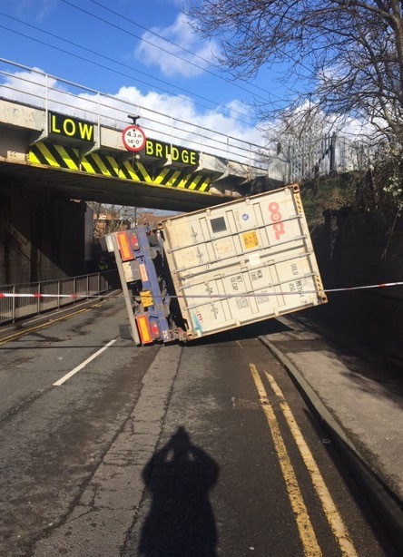 'Irresponsible' bridge-bash stupidity has got to stop 'Irresponsible' bridge-bash stupidity has got to stopRoute: London North Western Network Rail today called for an end to the entirely avoidable stupidity of lorry drivers who crash into bridges because they don’t know the height of their vehicles. The impassioned plea came after two ‘bridge strike’ incidents in the West Midlands yesterday (31 Jan) and two today in Cumbria and West London, all of which caused hours of delays to train customers and motorists. In the first incident in the West Midlands, shortly after midday yesterday, the lorry driver was lucky to escape unscathed after he smashed into the bridge on Summer Road in Erdington, Birmingham, before overturning. This despite clear signs showing the bridge's height. Trains on the Cross City Line north, between Birmingham New Street and Lichfield, Staffordshire, were disrupted for hours and local roads well into the evening. Trains on the route were further impacted when another lorry crashed into railway bridge on St John’s Street, Lichfield, just after 5.30pm. This bridge was struck 13 times in 2016/17. Today, two separate incidents in Langwathby, Cumbria, and West Ruislip, London, caused further unnecessary delays to passengers and motorists while Network Rail investigated for any damage before fully reopening the lines. Mark Killick, chief operating officer for Network Rail's London North Western route, said: “There’s no excuse for this. Lorry drivers should know their vehicle's height and width - not guess and hope for the best. "Despite being very clearly marked, these bridges were driven into by irresponsible drivers causing unnecessary disruption to railway and road-users. We will be doing all we can to reclaim the costs we incurred from the haulage companies responsible.” When a lorry ‘bridge strike’ occurs, Network Rail’s structural engineers always need to check the bridge is safe before train services can resume. The latest bridge strikes come despite Network Rail’s recently launched ‘What the Truck’ campaign, aimed at getting lorry drivers to know their vehicles’ heights and choose road routes accordingly. For more information on bridge strikes visit https://www.networkrail.co.uk/running-the-railway/looking-after-the-railway/bridges-tunnels-viaducts/risk-bridge-strikes/ |
|
|
|
|
Logged
|
|
|
|
|
Witham Bobby
|
|
« Reply #179 on: February 12, 2018, 17:41:16 » |
|
Apparently, the Good Burghers of Broadway in Worcestershire have got very het-up about the old A44 main road through the village having to be closed by the GWSR to effect repairs after bridge strikes, that they've tried to stick their oar in to prevent the running of a shuttle bus service between the station and the centre of the village. Idiots.
|
|
|
|
|
Logged
|
|
|
|
|