Coffee Shop - Tulse Hill Railway Station
Coffee Shop Home Page • About the Coffee Shop • Acronyms • Station Comparator • Calendar • New Topics • Popular Topics • MTUG • Coffee Shop Forum
Campaigning Home Page • Campaigning - list of daily tips • Campaigning - today's tip
Great Western Railway • Cross Country Trains • Chiltern Railways • South Western Railway • Transport for Wales • Transport for London
Tulse Hill Railway Station
| Live departures - links to current trains | National Rail or Real Time Trains or Tiger mobile view | ||||||||||||||||||||
| Postcode and link to map | SE27 9BW | ||||||||||||||||||||
| National Rail Timetable 2019 Summer | Table 052 Table 173 Table 179 Table 180 | ||||||||||||||||||||
| National Rail Timetable 2019/20 Winter | Table 052 Table 173 Table 179 Table 180 | ||||||||||||||||||||
| National Rail Timetable 2020 Summer | Table 052 Table 173 Table 179 Table 180 | ||||||||||||||||||||
| National Rail Timetable 2021 Summer | Table 052 Table 173 Table 179 Table 180 | ||||||||||||||||||||
| Fares to | |||||||||||||||||||||
| OS Grid Reference | TQ 317730 | ||||||||||||||||||||
Select here to go back to station index, or nearby:
| |||||||||||||||||||||
| 3 letter code | TUH | ||||||||||||||||||||
| Usage graph - stations in this postcode | [link] | ||||||||||||||||||||
| Search for Tulse Hill station | here | ||||||||||||||||||||
| 2004/5 Footfall | 950837 | ||||||||||||||||||||
| 2005/6 Footfall | 886932 (93% previous year) | ||||||||||||||||||||
| 2006/7 Footfall | 1464347 (165% previous year) | ||||||||||||||||||||
| 2007/8 Footfall | 1964216 (134% previous year) | ||||||||||||||||||||
| 2008/9 Footfall | 1800600 (91% previous year) | ||||||||||||||||||||
| 2009/10 Footfall | 1671756 (92% previous year) | ||||||||||||||||||||
| 2010/11 Footfall | 1849568 (110% previous year) | ||||||||||||||||||||
| 2011/12 Footfall | 1985746 (107% previous year) | ||||||||||||||||||||
| 2012/13 Footfall | 2145064 (108% previous year) | ||||||||||||||||||||
| 2013/14 Footfall | 2442126 (113% previous year) | ||||||||||||||||||||
| 2014/15 Footfall | 2597752 (106% previous year) | ||||||||||||||||||||
| 2015/16 Footfall | 2462898 (94% previous year) | ||||||||||||||||||||
| 2016/17 Footfall | 2178622 (88% previous year) | ||||||||||||||||||||
| 2017/18 Footfall | 2323478 (106% previous year) | ||||||||||||||||||||
| 2018/19 Footfall | 2363710 (101% previous year) | ||||||||||||||||||||
Select here to go to index
More about this data feed
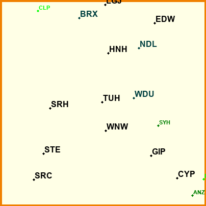
Nearby stations
Footfalls are for 2004/5 to 2018/19* TUH - Tulse Hill - 950837 / 886932 / 1464347 / 1964216 / 1800600 / 1671756 / 1849568 / 1985746 / 2145064 / 2442126 / 2597752 / 2462898 / 2178622 / 2323478 / 2363710 p.p.a. 229%
* WNW - West Norwood - 826002 / 794560 / 1421765 / 1845177 / 1706394 / 1734910 / 1940696 / 2094348 / 2073698 / 2118260 / 2265218 / 2221492 / 1937082 / 1921358 / 1938126 p.p.a. 234% - 1 mls away
WDU - West Dulwich - 580907 / 583287 / 834738 / 927190 / 871488 / 850554 / 909922 / 950166 / 949754 / 1025312 / 1104914 / 1169032 / 1121820 / 1078746 / 1100218 p.p.a. 193% - 1 mls away
HNH - Herne Hill - 1636337 / 1618701 / 2353890 / 2807629 / 2686386 / 2564060 / 2629368 / 2779942 / 2918610 / 3308970 / 3397698 / 2971220 / 2872992 / 2952022 / 2887852 p.p.a. 175% - 1 mls away
* SRH - Streatham Hill - 1274033 / 1274689 / 2004200 / 2355874 / 2137376 / 1996690 / 2322980 / 2684526 / 2661068 / 2725320 / 2813182 / 2634390 / 2223836 / 2152714 / 2176976 p.p.a. 174% - 2 mls away
SYH - Sydenham Hill - 310234 / 306100 / 499944 / 576209 / 559822 / 536984 / 574176 / 570736 / 585176 / 643928 / 700334 / 718502 / 748912 / 788890 / 824800 p.p.a. 241% - 2 mls away
* NDL - North Dulwich - 481719 / 479909 / 777135 / 743893 / 781498 / 798856 / 832814 / 851294 / 839378 / 869276 / 830808 / 799086 / 622984 / 680534 / 814444 p.p.a. 129% - 2 mls away
* GIP - Gipsy Hill - 1077284 / 1133747 / 1595174 / 1871823 / 1705800 / 1560968 / 1718698 / 1915066 / 1943522 / 1992136 / 2063946 / 1968148 / 1715420 / 1731828 / 1757758 p.p.a. 159% - 2 mls away
* STE - Streatham - 1178520 / 1143780 / 1723835 / 2501022 / 2192570 / 2015864 / 2179456 / 2301686 / 2396904 / 2883734 / 3194098 / 2926626 / 2707566 / 2810060 / 2812938 p.p.a. 229% - 2 mls away
BRX - Brixton - 381182 / 412621 / 652422 / 641523 / 656286 / 687127 / 785610 / 843776 / 896848 / 942548 / 1055340 / 1282232 / 1344198 / 1338068 / 1227746 p.p.a. 352% - 2 mls away
* EDW - East Dulwich - 719334 / 725479 / 1416608 / 1360087 / 1515942 / 1566010 / 1832872 / 2085892 / 2104766 / 2119018 / 1993304 / 1709704 / 1334640 / 1447360 / 1712462 p.p.a. 185% - 2 mls away
LGJ - Loughborough Junction - 301183 / 317371 / 1207246 / 924306 / 1033552 / 931228 / 1030700 / 1126082 / 1182914 / 1386290 / 1404552 / 892254 / 854826 / 975312 / 1004774 p.p.a. 283% - 2 mls away
* SRC - Streatham Common - 1874901 / 1897201 / 2994714 / 3282824 / 2942892 / 2977568 / 3346078 / 3612604 / 3668806 / 3827296 / 4003938 / 4865112 / 4077140 / 3889860 / 4023862 p.p.a. 217% - 2 mls away
* CYP - Crystal Palace - 905820 / 1038211 / 1466922 / 1670985 / 1619916 / 1627446 / 1868566 / 2126794 / 2201664 / 2473534 / 2772768 / 3626424 / 3646690 / 3644094 / 3691584 p.p.a. 402% - 3 mls away
* BAL - Balham - 3161416 / 3236366 / 5455384 / 5543764 / 5084538 / 5052242 / 5935140 / 6464028 / 6784734 / 6916220 / 7643798 / 10114526 / 8750756 / 8463278 / 8140418 p.p.a. 276% - 3 mls away
DMK - Denmark Hill - 1783521 / 1817818 / 2749255 / 3024744 / 3107894 / 3215916 / 3611562 / 3716804 / 3935776 / 5166040 / 5631008 / 7000860 / 7187152 / 7143688 / 6954844 p.p.a. 402% - 3 mls away
* NRB - Norbury - 1464984 / 1590579 / 2471819 / 2703720 / 2511114 / 2572018 / 2908954 / 3103480 / 3204748 / 3316630 / 3433808 / 4014210 / 3483382 / 3400742 / 3496376 p.p.a. 237% - 3 mls away
* CLP - Clapham High Street - 90840 / 101912 / 199646 / 242421 / 223936 / 238238 / 288158 / 316468 / 461490 / 1088500 / 1221838 / 2299688 / 2112006 / 1981564 / 1908680 p.p.a. 2324% - 3 mls away
* FOH - Forest Hill - 2033105 / 2006798 / 3014902 / 3127730 / 3022766 / 2945358 / 3643002 / 4183510 / 4487196 / 4665736 / 4661252 / 5264368 / 5422654 / 5222206 / 5291880 p.p.a. 266% - 3 mls away
* SYD - Sydenham - 1586028 / 1544882 / 2139553 / 2317031 / 2221310 / 2162656 / 2582386 / 2932598 / 3190706 / 3295764 / 3398180 / 4065740 / 4282154 / 4148354 / 4264916 p.p.a. 269% - 3 mls away
* PNW - Penge West - 247416 / 270751 / 195412 / 283536 / 245324 / 225938 / 360885 / 462018 / 506666 / 522334 / 519590 / 640978 / 696946 / 669002 / 683594 p.p.a. 281% - 3 mls away
* ANZ - Anerley - Data set not available p.p.a. 101% - 3 mls away
* WWR - Wandsworth Road - 64605 / 66787 / 164030 / 138798 / 166326 / 181014 / 239548 / 279248 / 312730 / 547786 / 617414 / 829908 / 812972 / 802902 / 779918 p.p.a. 1258% - 3 mls away
* WSW - Wandsworth Common - 821302 / 822024 / 1377136 / 1596175 / 1419254 / 1454954 / 1705476 / 1776140 / 1706724 / 1789040 / 1835084 / 1689888 / 1472394 / 1473800 / 1563122 p.p.a. 179% - 3 mls away
* PMR - Peckham Rye - 1552378 / 1580382 / 2569628 / 2502752 / 2570868 / 2646100 / 2987280 / 3272214 / 3670114 / 4665586 / 5074080 / 7520320 / 7464200 / 7333452 / 7295370 p.p.a. 480% - 3 mls away
PNE - Penge East - 689094 / 596134 / 1188497 / 1246170 / 1277718 / 1263669 / 1295226 / 1289590 / 1337416 / 1499414 / 1618298 / 1678574 / 1771312 / 1779570 / 1736186 p.p.a. 257% - 3 mls away
* HPA - Honor Oak Park - 981820 / 1023807 / 1582305 / 1614988 / 1461168 / 1525708 / 1898188 / 2217322 / 2412358 / 2492664 / 2541744 / 2969040 / 3071278 / 3048414 / 3155790 p.p.a. 312% - 3 mls away
TOO - Tooting - 629734 / 645316 / 1052365 / 1354500 / 1112464 / 944720 / 1000590 / 1065068 / 1083328 / 1317760 / 1451732 / 1222542 / 1028118 / 1050990 / 942892 p.p.a. 163% - 3 mls away
* TTH - Thornton Heath - 1785882 / 1816383 / 2365090 / 2593059 / 2377258 / 2383818 / 2633274 / 2848670 / 2970480 / 3073494 / 3266642 / 3856500 / 3390804 / 3327476 / 3277862 p.p.a. 189% - 3 mls away
NHD - Nunhead - 443990 / 425168 / 800341 / 895708 / 924678 / 926852 / 1012106 / 1056840 / 1082502 / 1235124 / 1286764 / 1196148 / 1156716 / 1170738 / 1177414 p.p.a. 260% - 3 mls away
QRB - Queenstown Road (Battersea) - 191408 / 234932 / 851667 / 1157044 / 995926 / 1054662 / 1249122 / 1358536 / 1441132 / 1457410 / 1559150 / 1757632 / 1825396 / 1496050 / 1660516 p.p.a. 953% - 4 mls away
* QRP - Queens Road, Peckham - 387713 / 386716 / 691650 / 680597 / 717998 / 745326 / 897362 / 1024608 / 1170518 / 1585240 / 1790786 / 2846634 / 2824384 / 3027870 / 3311738 p.p.a. n/a% - 4 mls away
Total of these stations (2006/7 to 2007/8) - 51798248 -> 59016316 (113%)
Some similar stations (passenger No.s)
Footfalls are for 2004/5 to 2018/19* TUH - Tulse Hill - 950837 / 886932 / 1464347 / 1964216 / 1800600 / 1671756 / 1849568 / 1985746 / 2145064 / 2442126 / 2597752 / 2462898 / 2178622 / 2323478 / 2363710 p.p.a. 229%
HUD - Huddersfield - 2214165 / 2386280 / 2511072 / 2672469 / 3565582 / 3578080 / 4095240 / 4199980 / 4656700 / 4816107 / 4994344 / 5041600 / 5092542 / 5100976 / 4897612 p.p.a. 229% - 169 mls away
BIC - Billericay - 2698460 / 2766934 / 2791639 / 2840285 / 2833474 / 2631346 / 2755782 / 2807418 / 2942476 / 3017148 / 3106750 / 3104220 / 3070934 / 3030166 / 3043344 p.p.a. 113% - 27 mls away
CDQ - Cardiff Queen Street - 2072551 / 2126479 / 2231784 / 2486005 / 2559748 / 2437638 / 2411438 / 2488932 / 2495238 / 2462700 / 2523314 / 2643568 / 2850984 / 2912364 / 3431518 p.p.a. 137% - 133 mls away
CRE - Crewe - 1528562 / 1652040 / 1750043 / 1900155 / 1954478 / 2034546 / 2246474 / 2351476 / 2443714 / 2511958 / 2650534 / 2843396 / 3085604 / 3147094 / 3317760 p.p.a. 201% - 151 mls away
SWI - Swindon - 2257719 / 2340952 / 2515492 / 2758891 / 2905266 / 2835364 / 3039228 / 3234682 / 3220180 / 3350444 / 3503982 / 3580540 / 3679242 / 3625360 / 3756422 p.p.a. 162% - 73 mls away
HRO - Harold Wood - 1770874 / 1773086 / 3014836 / 3476002 / 3042946 / 2808636 / 2552716 / 2580200 / 2857572 / 2917788 / 3140072 / 2929974 / 2973440 / 2929720 / 3088968 p.p.a. 167% - 19 mls away
SNS - Staines - 2023639 / 2097188 / 2250362 / 2629739 / 2756660 / 2717060 / 2799298 / 2898060 / 2825096 / 2849914 / 2881160 / 2777174 / 2771474 / 2753456 / 2867034 p.p.a. 136% - 18 mls away
BKH - Blackheath - 1980817 / 2005382 / 2739811 / 2935004 / 2779272 / 2739618 / 2863788 / 2878152 / 2929406 / 3055518 / 3226102 / 3448280 / 3468992 / 3350574 / 3274008 p.p.a. 175% - 6 mls away
BKJ - Beckenham Junction - 1760816 / 1864281 / 2444386 / 2765028 / 2668134 / 2564452 / 2633876 / 2625656 / 2677450 / 2761006 / 2794134 / 2713014 / 2777104 / 2780258 / 2705700 p.p.a. 157% - 4 mls away
GRV - Gravesend - 2246740 / 2358121 / 2482275 / 2786078 / 2712350 / 2502232 / 2647486 / 2706808 / 2646234 / 2616257 / 2772440 / 2932030 / 2984420 / 2989304 / 3087304 p.p.a. 132% - 21 mls away
GDP - Gidea Park - 1689192 / 1670663 / 2703604 / 3172538 / 2587398 / 2401226 / 2467414 / 2524442 / 2587142 / 2810806 / 2944838 / 2860546 / 2797104 / 2711136 / 2833972 p.p.a. 165% - 17 mls away
SPT - Stockport - 1608240 / 2011910 / 2237758 / 2439503 / 2824472 / 2933346 / 3138634 / 3312992 / 3367276 / 3505408 / 3411494 / 3586032 / 3781718 / 3853208 / 4439842 p.p.a. 235% - 162 mls away
HPD - Harpenden - 2534192 / 2612071 / 2806145 / 2929986 / 2932688 / 2771680 / 2884834 / 2999770 / 3126064 / 3182292 / 3315890 / 3337170 / 3356144 / 3356988 / 3373086 p.p.a. 132% - 29 mls away
GRY - Grays - 2373714 / 2380928 / 2600195 / 2884353 / 2862204 / 2788040 / 2834606 / 2971578 / 3091184 / 3223994 / 3470600 / 3819352 / 3984598 / 4053092 / 4165432 p.p.a. 167% - 19 mls away
* CCH - Chichester - 2265876 / 2401077 / 2599788 / 2762838 / 2889964 / 2984494 / 3144194 / 3190574 / 3236004 / 3269044 / 3232654 / 3231354 / 2608084 / 2841842 / 2977098 p.p.a. 115% - 52 mls away
* FOH - Forest Hill - 2033105 / 2006798 / 3014902 / 3127730 / 3022766 / 2945358 / 3643002 / 4183510 / 4487196 / 4665736 / 4661252 / 5264368 / 5422654 / 5222206 / 5291880 p.p.a. 266% - 3 mls away
BEF - Benfleet - 2447625 / 2448898 / 2480038 / 2989139 / 2997824 / 2844178 / 2886164 / 3547130 / 3505946 / 3401023 / 3421246 / 3723078 / 3844366 / 3680038 / 3664766 p.p.a. 157% - 30 mls away
* STE - Streatham - 1178520 / 1143780 / 1723835 / 2501022 / 2192570 / 2015864 / 2179456 / 2301686 / 2396904 / 2883734 / 3194098 / 2926626 / 2707566 / 2810060 / 2812938 p.p.a. 229% - 2 mls away
IPS - Ipswich - 2017300 / 2144935 / 2402052 / 2807395 / 2825352 / 2774536 / 3004678 / 3159316 / 3348394 / 3312522 / 3295398 / 3284934 / 3342366 / 3351902 / 3416026 p.p.a. 165% - 69 mls away
WCP - Worcester Park - 1471082 / 1453302 / 2688280 / 2790533 / 2605318 / 2539716 / 2655248 / 2683706 / 2715944 / 2746968 / 2745468 / 2442322 / 2366392 / 2198960 / 2359004 p.p.a. 160% - 8 mls away
UPM - Upminster - 3437977 / 3331240 / 2538483 / 2950726 / 2555062 / 3018822 / 3991538 / 4190524 / 4393238 / 4529774 / 4932170 / 5624208 / 5984006 / 5962402 / 5909882 p.p.a. 174% - 18 mls away
LTN - Luton Airport Parkway - 1886911 / 2156699 / 2364740 / 2628187 / 2589262 / 2338658 / 2312120 / 2429604 / 2504794 / 2567224 / 2754700 / 3188146 / 3819812 / 3965208 / 4148530 p.p.a. 202% - 33 mls away
SIT - Sittingbourne - 1909992 / 1935723 / 2028590 / 2166116 / 2214758 / 2034546 / 2050928 / 2019744 / 1949484 / 1965579 / 2063382 / 2111046 / 2164064 / 2223636 / 2295150 p.p.a. 113% - 37 mls away
WVH - Wolverhampton - 2058706 / 2254742 / 2399955 / 2510429 / 4221010 / 4280096 / 4454566 / 4189164 / 4207032 / 4406594 / 4495936 / 4746338 / 4920356 / 4993372 / 5305828 p.p.a. 239% - 117 mls away
GLM - Gillingham (Kent) - 1985141 / 2033034 / 2200842 / 2348656 / 2371132 / 2305746 / 2409294 / 2433346 / 2408408 / 2439280 / 2540188 / 2629244 / 2731126 / 2744182 / 2747444 p.p.a. 137% - 29 mls away
* WCY - West Croydon - 717035 / 651164 / 2910721 / 2926915 / 2705560 / 2556270 / 3323197 / 3870408 / 4300582 / 4280342 / 4488068 / 5112632 / 5532442 / 5371898 / 5419354 p.p.a. 771% - 5 mls away
* PUR - Purley - 1902437 / 1891142 / 2523920 / 2734681 / 2563738 / 2578022 / 2675454 / 2755796 / 2917722 / 3064170 / 3205666 / 3350714 / 3029276 / 3076294 / 3004052 p.p.a. 159% - 8 mls away
FNB - Farnborough (Main) - 2359794 / 2412636 / 2748039 / 2654016 / 2860316 / 2737240 / 2969782 / 3015560 / 2859700 / 2930052 / 3081070 / 2990294 / 3040325 / 2947664 / 3112336 p.p.a. 128% - 30 mls away
* TBD - Three Bridges - 2011517 / 2070096 / 2246613 / 2407558 / 2474852 / 2475106 / 2701820 / 2879950 / 3005312 / 3160332 / 3229830 / 3173378 / 3071680 / 3069270 / 3223574 p.p.a. 152% - 23 mls away
NWP - Newport (S. Wales) - 1828189 / 1906008 / 2011630 / 2155283 / 2160498 / 2181630 / 2291040 / 2273932 / 2250258 / 2291044 / 2388504 / 2560868 / 2614150 / 2696620 / 2846440 p.p.a. 142% - 126 mls away
* HOV - Hove - 1764870 / 1917565 / 2096836 / 2184921 / 2302638 / 2259680 / 2321434 / 2391926 / 2400344 / 2421536 / 2453194 / 2451660 / 2043206 / 2232664 / 2332418 p.p.a. 115% - 42 mls away
Total of these stations (2006/7 to 2007/8) - 85112602 -> 90918840 (106%)
Great Western Coffee Shop Forum
17 years, 3340 members, 25823 topics, 342876 individual posts. Our forum is lively and active - and friendly too. It's run by passengers, for passengers. Visit us at www.passenger.chatYou are on our passenger support pages which cover information of general interest to public transport passengers.
Popular Links
-
 Coffee Shop
Great Western Passenger forum -
 Melksham Transport User Group
-
 MTUG Facebook
Visit MTUG on Facebook -
 TravelWatch SouthWest
Co-ordinating User's voices -
 Great Western Railway
Your Train Operator -
 Community Rail Network
(Formerly ACoRP)
Most Popular Recent Topics
Members logged in - last 8 and 24 hours - 36, 85Members, threads, posts - 3340 , 25823, 342876
[*] You see all sorts on the bus.
[*] "Mayflower"
[*] On reservations, fees and supplements - Interrail
[*] Somerset and Dorset Devonshire Tunnel flood
[*] Rail to refuge / Travel to refuge
[*] Ticket machines
[*] Where have I been?
[*] "We can’t get from A to B in Britain and it might just be the Governme ...
[*] Rail delay compensation payments hit £100 million