


| Re: Weather updates from across the UK, with implications for infrastructure - ongoing discussion, 2 Posted by Chris from Nailsea at 09:55, 26th January 2026 |     |
Another update, from the BBC:
Body found believed to be missing antiques dealer

A body recovered from the sea is believed to be missing antiques dealer Matthew Upham
The body of a man recovered from the sea is thought to be antiques shop owner Matthew Upham, one of two swimmers who went missing on Christmas Day.
Devon and Cornwall Police said emergency services were called to Exmouth Beach in Devon just before 15:00 GMT on Sunday following a report of a body seen near the shore. Formal identification is yet to be carried out, but officers said the family of a 64-year-old man from Budleigh Salterton had been informed.
The body of a 47-year-old man, thought to be the other swimmer who went missing, was recovered on Tuesday.
Upham, 64, owner of an antiques shop in Budleigh Salterton, Devon, was previously named by his family as one of the swimmers. According to his friend, singer-songwriter Kate Bush, he had gone into the sea to help a woman in difficulty. "Matthew is deeply loved and will be forever missed," said his family, thanking emergency services who responded.
Emergency services were called to Budleigh Salterton shortly after 10:25 GMT on 25 December after two men could not be located. The coastguard search operation was called off at about 17:00.
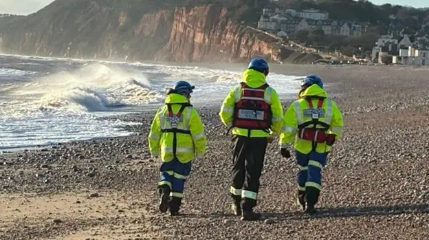
RNLI crews as well as coastguard helicopters carried out extensive shoreline and offshore searches and a number of people were safely brought back to shore. They were checked either by paramedics at the scene or taken to hospital as a precaution.
Organisers of some Christmas and Boxing Day swims in Devon and Cornwall had postponed or cancelled events due to a yellow weather warning for wind.
A body recovered from the sea is believed to be missing antiques dealer Matthew Upham
The body of a man recovered from the sea is thought to be antiques shop owner Matthew Upham, one of two swimmers who went missing on Christmas Day.
Devon and Cornwall Police said emergency services were called to Exmouth Beach in Devon just before 15:00 GMT on Sunday following a report of a body seen near the shore. Formal identification is yet to be carried out, but officers said the family of a 64-year-old man from Budleigh Salterton had been informed.
The body of a 47-year-old man, thought to be the other swimmer who went missing, was recovered on Tuesday.
Upham, 64, owner of an antiques shop in Budleigh Salterton, Devon, was previously named by his family as one of the swimmers. According to his friend, singer-songwriter Kate Bush, he had gone into the sea to help a woman in difficulty. "Matthew is deeply loved and will be forever missed," said his family, thanking emergency services who responded.
Emergency services were called to Budleigh Salterton shortly after 10:25 GMT on 25 December after two men could not be located. The coastguard search operation was called off at about 17:00.
RNLI crews as well as coastguard helicopters carried out extensive shoreline and offshore searches and a number of people were safely brought back to shore. They were checked either by paramedics at the scene or taken to hospital as a precaution.
Organisers of some Christmas and Boxing Day swims in Devon and Cornwall had postponed or cancelled events due to a yellow weather warning for wind.
| Re: Weather updates from across the UK, with implications for infrastructure - ongoing discussion, 2 Posted by Chris from Nailsea at 14:14, 22nd January 2026 | |
I used to play rugby with Ryan Doyle, he's certainly risen through the ranks!
Many years ago now, I served together with a police constable in Bristol. Fairly recently, he retired as Chief Superintendent in charge of CID Anti-Terrorism.
He lives in Nailsea.

| Re: Weather updates from across the UK, with implications for infrastructure - ongoing discussion, 2 Posted by TaplowGreen at 13:57, 22nd January 2026 | |
An update, from the BBC:
One of two missing Christmas Day swimmers found
The body of a 47-year-old man has been recovered after two swimmers went missing on Christmas Day, police have said.
Officers said they found the man at Sandy Bay near Exmouth on Tuesday after two swimmers went missing in stormy seas at Budleigh Salterton, Devon, on 25 December.
Formal identification is yet to be carried out, but officers said they believe the person to be a 47-year-old man. His next-of-kin have been informed. One of the swimmers was named as 64-year-old local antiques dealer Matthew Upham.
Supt Ryan Doyle, from Devon and Cornwall Police, said the discovery was "very sad news". He added: "We have spoken with his family and we are continuing to support them through this difficult time. Understandably they have asked for their privacy to be respected. The family of the second missing man has also been informed and are being supported."
(BBC article continues)
I used to play rugby with Ryan Doyle, he's certainly risen through the ranks!
| Re: Weather updates from across the UK, with implications for infrastructure - ongoing discussion, 2 Posted by Chris from Nailsea at 13:00, 22nd January 2026 | |
With thanks for your latest post here, ChrisB, I will now move it into the 2026 weather topic.
My own previous post here related to the sad recovery of the body of one of the two men who died on Christmas Day 2025.
| Re: Weather updates from across the UK, with implications for infrastructure - ongoing discussion, 2 Posted by Chris from Nailsea at 18:11, 21st January 2026 | |
An update, from the BBC:
One of two missing Christmas Day swimmers found
The body of a 47-year-old man has been recovered after two swimmers went missing on Christmas Day, police have said.
Officers said they found the man at Sandy Bay near Exmouth on Tuesday after two swimmers went missing in stormy seas at Budleigh Salterton, Devon, on 25 December.
Formal identification is yet to be carried out, but officers said they believe the person to be a 47-year-old man. His next-of-kin have been informed. One of the swimmers was named as 64-year-old local antiques dealer Matthew Upham.
Supt Ryan Doyle, from Devon and Cornwall Police, said the discovery was "very sad news". He added: "We have spoken with his family and we are continuing to support them through this difficult time. Understandably they have asked for their privacy to be respected. The family of the second missing man has also been informed and are being supported."
(BBC article continues)
The body of a 47-year-old man has been recovered after two swimmers went missing on Christmas Day, police have said.
Officers said they found the man at Sandy Bay near Exmouth on Tuesday after two swimmers went missing in stormy seas at Budleigh Salterton, Devon, on 25 December.
Formal identification is yet to be carried out, but officers said they believe the person to be a 47-year-old man. His next-of-kin have been informed. One of the swimmers was named as 64-year-old local antiques dealer Matthew Upham.
Supt Ryan Doyle, from Devon and Cornwall Police, said the discovery was "very sad news". He added: "We have spoken with his family and we are continuing to support them through this difficult time. Understandably they have asked for their privacy to be respected. The family of the second missing man has also been informed and are being supported."
(BBC article continues)
| Re: Weather updates from across the UK, with implications for infrastructure - ongoing discussion, 2025 Posted by ChrisB at 19:08, 26th December 2025 | |
One now named .....
From the BBC
Family of man missing at sea pay tribute
One of the swimmers who went missing during a Christmas Day swim has been named on social media.
Family of Matthew Upham, owner of an antiques shop in Budleigh Salterton, Devon, issued a statement on his Instagram business page.
Emergency services had been searching for the area after two men in their 60s and 40s went missing in the sea at Budleigh Salterton on Thursday shortly after 10:25 GMT. The coastguard search operation was called off at around 17:00.
The statement on the business's Instagram story, external read: "Our family is heartbroken by the loss of our beloved family member Matthew Upham, who was reported missing on Christmas morning."

| Re: Weather updates from across the UK, with implications for infrastructure - ongoing discussion, 2025 Posted by Chris from Nailsea at 17:30, 26th December 2025 | |
From the BBC:
Search called off for two swimmers missing at sea

Flowers have been laid close to where the men went missing
Flowers have been laid close to where the men went missing
| Re: Weather updates from across the UK, with implications for infrastructure - ongoing discussion, 2025 Posted by ChrisB at 16:45, 26th December 2025 | |
This is what happens when there's country-wide warnings issued - cold Health, weather, Mountains, RNLI, etc etc...
A traditional event with no organisation in charge happens on a certain day. No warnings put out so everyone has a SatNav moment - regardless of whether/weather one can see a problem, they do it anyway....
Dangerous things, those warnings....
| Re: Weather updates from across the UK, with implications for infrastructure - ongoing discussion, 2025 Posted by GBM at 12:47, 26th December 2025 | |
Too easy to speculate here
| Re: Weather updates from across the UK, with implications for infrastructure - ongoing discussion, 2025 Posted by Chris from Nailsea at 12:39, 26th December 2025 | |
A sad news update, from the BBC:
Search called off for two swimmers missing at sea
Two men remain missing after a Christmas Day swim at Budleigh Salterton, Devon
A coastguard search operation for two men who went missing in the sea during a Christmas Day swim has been called off.
Emergency services were called to Budleigh Salterton, in Devon, shortly after 10:25 GMT on Thursday.
While some people were brought back to shore, two men in their 40s and 60s could not be located.
The coastguard stopped searching the water at 17:00, but police said on-shore enquiries continued into the evening. The men's families have been informed.
While there is no official weather warning in place on Boxing Day, some sea swims have been cancelled and police in Devon and Cornwall have urged people not to get into the water.
Residents of the small town have described the incident as "shocking" and "tragic".
"I've never quite witnessed anything like this," said John Smyley, who lives close to the beach. He described it as a "particularly cold day" in the town and said the sea "looked ferocious".
"It's very shocking and it's sad - particularly on Christmas Day," he added.
...
Det Supt Hayley Costar from Devon and Cornwall Police described the incident as "truly tragic" in a statement on Thursday. "Our thoughts remain firmly with the families and friends of the two men who are currently missing and to all who may have witnessed and been impacted by the incident," she added.
In a post on social media, Budleigh Salterton Baptist Church said its prayers are with the men's families and friends as well as emergency services. It said: "We are sad to hear the devastating news of the two men missing after yesterday's swim. If you would like to pray or talk to someone at this difficult time, please don't hesitate to get in touch."
| Re: Weather updates from across the UK, with implications for infrastructure - ongoing discussion, 2025 Posted by Chris from Nailsea at 13:01, 25th December 2025 | |
Rather shockingly, only minutes later, from the BBC:
Swimmers rescued amid ongoing emergency response
A significant emergency service response has begun after reports of a number of people getting into difficulty in the water off the Devon coast.
Police were called at 10:25 GMT to the beach at Budleigh Salterton after concern was raised for people in the water.
A number of people have been safely brought back to shore and will be checked by paramedics, Devon and Cornwall Police have confirmed.
The Maritime and Coastguard Agency said Exmouth and Beer Coastguard Rescue teams, RNLI lifeboats from Exmouth and Torbay, and coastguard search and rescue helicopters have been sent to the scene to assist, alongside police and the ambulance service.
Members of the public have been urged to not enter the water along this stretch of coast while the incident is ongoing.
| Re: Weather updates from across the UK, with implications for infrastructure - ongoing discussion, 2025 Posted by Chris from Nailsea at 12:52, 25th December 2025 | |
From the BBC:
Cold health alert as parts of UK set to freeze on Christmas Day
A cold health alert and weather warnings have been issued for parts of the UK on Christmas Day, as forecasters dashed hopes of a white Christmas.
The UK Health Security Agency (UKHSA) issued the yellow alert for south-west England from 18:00 on 25 December to midday on 27 December.
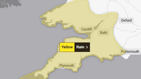
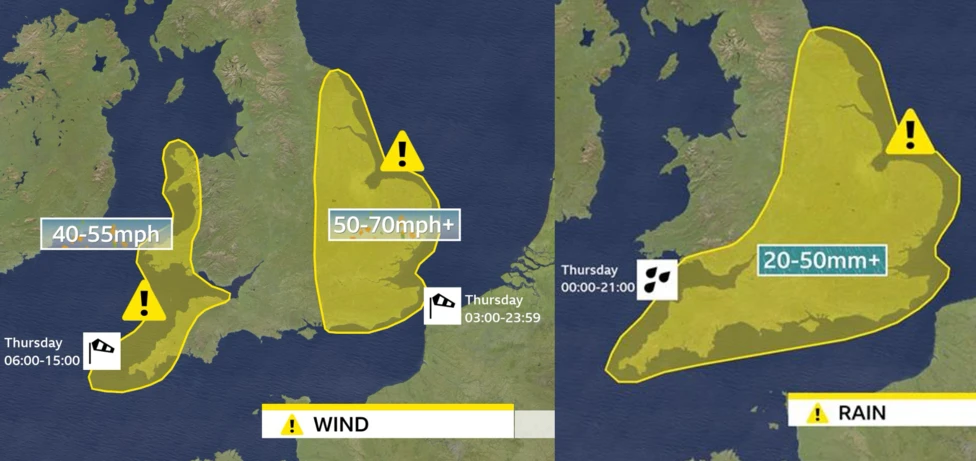
A Met Office yellow warning for wind covers south-west England, Somerset and a large swathe of Wales, stretching from Cardiff and Swansea up to Bangor. Gusts hit 68mph (109 km/h) early on Thursday at Berry Head, Torbay.
Organisers of some Christmas and Boxing Day swims in Devon and Cornwall have had to cancel events.
In total, the Met Office warning covers 18 of Wales' 22 council areas.
In south-west England, temperatures on Christmas morning were between 1C and 4C (34F and 39F) for most, said BBC Weather's Matt Taylor, but it was "feeling below freezing due to the wind chill". Winds around coasts and on moors have exceeded 40mph at times, hitting 43mph at Plymouth and 49mph at Liscombe, Exmoor, he added.
Met Office spokesman Oli Claydon said it was "highly unlikely" the UK would see a white Christmas. "We've got a very dry picture across the UK over the next few days," he added.
Although not an official part of the UK, the crown dependency of Jersey experienced snow on Thursday morning. The Jersey Met Section said it was only the third time since records began that snow was observed on the island on Christmas Day and the first time since 1970.
...
The highest temperatures on Christmas Day were forecast to be around 7C (45F) in north-east England and 6C in south or south-east England. The Met Office added that frost and freezing temperatures were likely in western rural areas overnight on Christmas Day into Boxing Day, with -6C possible in rural parts of Scotland and -4C in rural Wales.
Organisers of the Coverack swim in Cornwall said with the weather forecast it would be "too dangerous" for the event to go ahead and postponed the event until New Year's Day. Start Bay Inn, in Devon, said it was "really sad" to announce its Boxing Day swim had been cancelled, while the RNLI Teignmouth took a similar decision, insisting "safety considerations must come first".
A cold health alert and weather warnings have been issued for parts of the UK on Christmas Day, as forecasters dashed hopes of a white Christmas.
The UK Health Security Agency (UKHSA) issued the yellow alert for south-west England from 18:00 on 25 December to midday on 27 December.
A Met Office yellow warning for wind covers south-west England, Somerset and a large swathe of Wales, stretching from Cardiff and Swansea up to Bangor. Gusts hit 68mph (109 km/h) early on Thursday at Berry Head, Torbay.
Organisers of some Christmas and Boxing Day swims in Devon and Cornwall have had to cancel events.
In total, the Met Office warning covers 18 of Wales' 22 council areas.
In south-west England, temperatures on Christmas morning were between 1C and 4C (34F and 39F) for most, said BBC Weather's Matt Taylor, but it was "feeling below freezing due to the wind chill". Winds around coasts and on moors have exceeded 40mph at times, hitting 43mph at Plymouth and 49mph at Liscombe, Exmoor, he added.
Met Office spokesman Oli Claydon said it was "highly unlikely" the UK would see a white Christmas. "We've got a very dry picture across the UK over the next few days," he added.
Although not an official part of the UK, the crown dependency of Jersey experienced snow on Thursday morning. The Jersey Met Section said it was only the third time since records began that snow was observed on the island on Christmas Day and the first time since 1970.
...
The highest temperatures on Christmas Day were forecast to be around 7C (45F) in north-east England and 6C in south or south-east England. The Met Office added that frost and freezing temperatures were likely in western rural areas overnight on Christmas Day into Boxing Day, with -6C possible in rural parts of Scotland and -4C in rural Wales.
Organisers of the Coverack swim in Cornwall said with the weather forecast it would be "too dangerous" for the event to go ahead and postponed the event until New Year's Day. Start Bay Inn, in Devon, said it was "really sad" to announce its Boxing Day swim had been cancelled, while the RNLI Teignmouth took a similar decision, insisting "safety considerations must come first".
I know that one of my fellow administrators on this forum is in Teignmouth today: to him, please take note of the final paragraph in that BBC article, and do not venture out into the sea.

CfN.

| Re: Weather updates from across the UK, with implications for infrastructure - ongoing discussion, 2025 Posted by Chris from Nailsea at 14:15, 20th December 2025 | |
From the BBC:
Heavy rainfall helps West Country recover from prolonged dry spell
England experienced the second driest six-month period (from March to August) since records began in 1871
Recent heavy rainfall has pulled the west of England into "recovery" status following an extensive dry spell.
Prolonged dry weather status – a precursor to drought – was announced on 10 July by the Environment Agency (EA) for its Wessex area, which includes Bristol, Somerset, Dorset, Wiltshire and parts of south Gloucestershire. The warning followed the driest spring in a century and the hottest summer on record - a combination which depleted water reserves and triggered hosepipe bans.
Now the EA has revealed most of the West Country's water situation is recovering, with Wiltshire to follow suit once groundwater levels recharge.
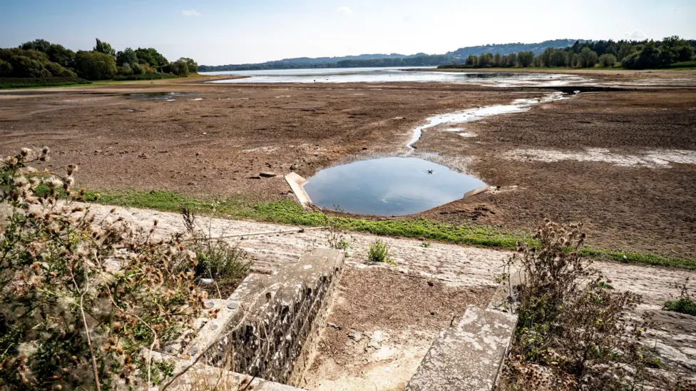
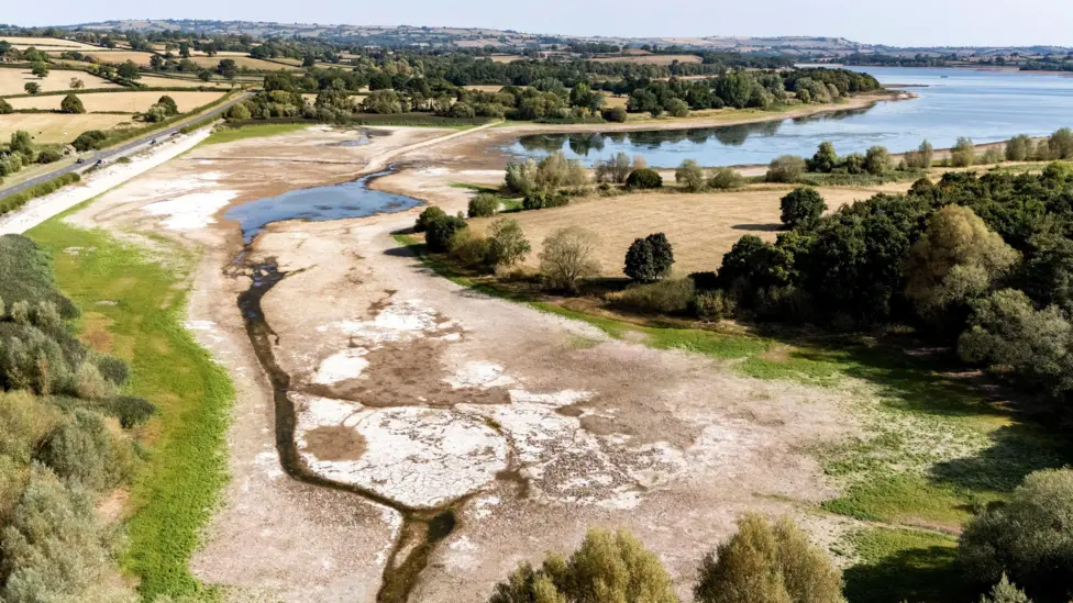
A dry spring and summer exposed the parched lake bed at Chew Valley reservoir
If below-average rainfall had continued, drought was expected in the West Country next March. But in a dramatic turnaround, September saw 142% of the long-term average rainfall, followed by 128% in November and a similarly wet start to December.
The EA confirmed "high river flows and the partial refilling of water company reservoirs are signs that the water situation is improving".
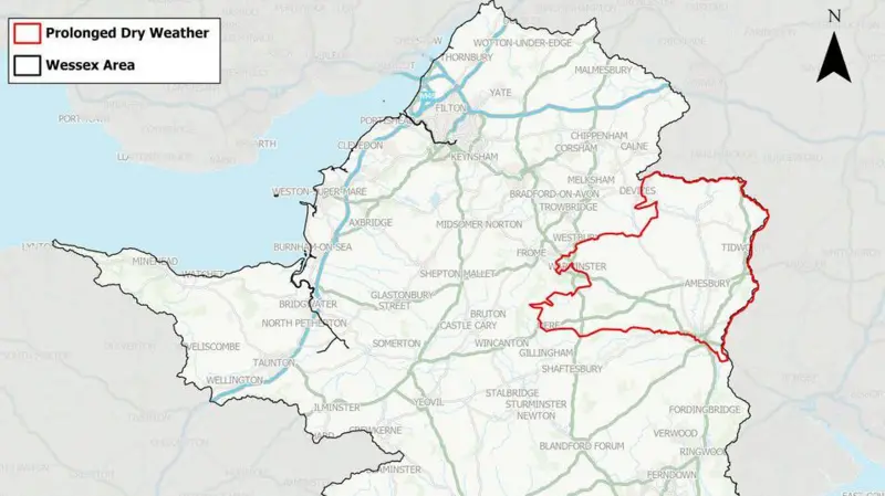
Parts of Wiltshire, indicated by the red outline, are to remain in prolonged dry weather status until the groundwater aquifer recharges
However, groundwater levels in the chalk aquifer - a vast underground store of fresh water - below the upper Hampshire Avon in Wiltshire remain "exceptionally low", the agency added. It said underground aquifers provide much of our drinking water, and these need to be replenished over several months. This area from Devizes down to Salisbury will remain in prolonged dry weather status until the aquifer is recharged.
Ian Withers, EA area director for Wessex, said: "The return of heavy rain has benefited the environment after a very dry period. But there is no guarantee that sustained rainfall will continue. We still need a wet winter to prevent the water situation from deteriorating again. The risk of flooding remains even during a drought. Stay alert, follow flood warning guidance and be ready to deploy any personal property protection," he added.
Reservoir levels for Wessex Water and Bristol Water, as of 15 December, were 94% and 77%, respectively.
England experienced the second driest six-month period (from March to August) since records began in 1871
Recent heavy rainfall has pulled the west of England into "recovery" status following an extensive dry spell.
Prolonged dry weather status – a precursor to drought – was announced on 10 July by the Environment Agency (EA) for its Wessex area, which includes Bristol, Somerset, Dorset, Wiltshire and parts of south Gloucestershire. The warning followed the driest spring in a century and the hottest summer on record - a combination which depleted water reserves and triggered hosepipe bans.
Now the EA has revealed most of the West Country's water situation is recovering, with Wiltshire to follow suit once groundwater levels recharge.
A dry spring and summer exposed the parched lake bed at Chew Valley reservoir
If below-average rainfall had continued, drought was expected in the West Country next March. But in a dramatic turnaround, September saw 142% of the long-term average rainfall, followed by 128% in November and a similarly wet start to December.
The EA confirmed "high river flows and the partial refilling of water company reservoirs are signs that the water situation is improving".
Parts of Wiltshire, indicated by the red outline, are to remain in prolonged dry weather status until the groundwater aquifer recharges
However, groundwater levels in the chalk aquifer - a vast underground store of fresh water - below the upper Hampshire Avon in Wiltshire remain "exceptionally low", the agency added. It said underground aquifers provide much of our drinking water, and these need to be replenished over several months. This area from Devizes down to Salisbury will remain in prolonged dry weather status until the aquifer is recharged.
Ian Withers, EA area director for Wessex, said: "The return of heavy rain has benefited the environment after a very dry period. But there is no guarantee that sustained rainfall will continue. We still need a wet winter to prevent the water situation from deteriorating again. The risk of flooding remains even during a drought. Stay alert, follow flood warning guidance and be ready to deploy any personal property protection," he added.
Reservoir levels for Wessex Water and Bristol Water, as of 15 December, were 94% and 77%, respectively.
Posting personally here, as a long-time resident in this area: I have never seen the water level in the Chew Valley Lake as low as it was in those images from earlier this year. CfN.

| Re: Weather updates from across the UK, with implications for infrastructure - ongoing discussion, 2025 Posted by Chris from Nailsea at 17:12, 6th December 2025 | |
From the BBC:
Met Office issues weather warning for rain, 8-9 December
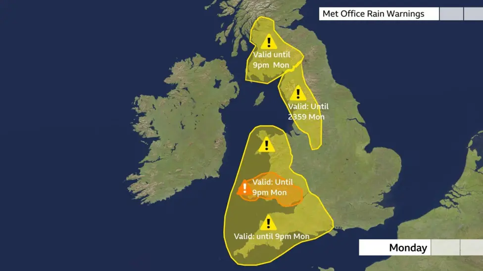
Areas of England and Wales have been warned of potential flooding and travel disruption caused by heavy rain.
The Met Office issued a yellow weather warning for south west England and south Wales earlier, which will be in place from 18:00 GMT on Monday to 18:00 on Tuesday.
The forecaster said an area of low pressure approaching the UK from the south west would bring heavy rain as well as strong winds, which could last until early Wednesday.
"At present, the exact track, depth, and timings of this low are uncertain, which makes it harder to determine where will be most impacted by strong winds and/or heavy rain," said Steven Keates, the Met Office's deputy chief meteorologist.
"This system has the potential to cause disruption, and severe weather warnings are likely to be issued over the weekend as details become clearer," he added.
Outbreaks of rain will become persistent and heavy, the Met Office said, with up to 40mm (1.6in) of rainfall in some areas and 60-80mm of rain over Dartmoor and high ground in south Wales, which could amount to more than half the average monthly rainfall in December.
Spray and flooding on the roads could cause difficult driving conditions, the forecaster said, with a chance of cancellations to train and bus services.
There is a small chance of some communities being cut off by flooded roads, as well as of homes and businesses being damaged by rising water.
The Met Office warning also highlights the possibility of fast flowing water causing danger to life, with some areas also facing the potential of power cuts.
The weather warning covers much of the south-west of England and south Wales.
(BBC article continues)
| Re: Weather updates from across the UK, with implications for infrastructure - ongoing discussion, 2025 Posted by Chris from Nailsea at 20:14, 1st December 2025 | |
From the BBC:
Danger to life and flood warning as heavy rain hits again
The Afon Glaslyn has risen close to the top of the wall surrounding this house in Beddgelert, Gwynedd
Heavy rain could cause "disruption and probable flooding" on Monday with an amber weather warning in place for south Wales.
The Met Office said heavy rain was expected over south Wales from late Sunday and throughout Monday, with 20-40mm (0.78-1.58in) expected across the wider region and 100-120mm (3.9-4.7in) in a few places on higher ground.
A yellow warning of rain is also in place for mid and north Wales on Monday, with the Afon Glaslyn in Beddgelert, Gwynedd, nearly broaching the garden wall of a house nearby.
The weather alerts come two weeks after danger to life flood warnings were issued and homes and businesses in Monmouth and elsewhere hit after rivers burst their banks.
(BBC news item continues)
| Re: Weather updates from across the UK, with implications for infrastructure - ongoing discussion, 2025 Posted by Chris from Nailsea at 16:04, 1st December 2025 | |
From the BBC:
Weather warnings issued as heavy rain hits the UK with flooding expected
Heavy rain is expected to bring flooding and disruption across large parts of the UK on Monday.
An amber Met Office severe weather warning for rain is in force across south Wales, while multiple yellow warnings are in force for many western areas of the UK.
Nearly a month's worth of rain could fall onto already very saturated ground after above average rainfall throughout November across England and Wales. There will also be some gusty winds, especially around coastal areas.
Winter - meteorologically speaking - has started on a very wet note with rain across much of the UK. That trend is likely to continue for most of Monday and turn particularly heavy at times. Rainfall totals will build quite widely but with very saturated ground there are numerous yellow Met Office warnings in force.
A more severe amber Met Office warning is in force for south Wales until 21:00 GMT. Between 20 and 40mm (0.8 and 1.6in) of rain is expected to fall widely here, with some south-western facing hills seeing nearer to 120mm (4.7in).
The average rainfall for south Wales and south-west England for the whole of December is 152mm (6in)
Extensive flooding is possible along with disruption on the road and rail network, loss of power and communities potentially cut off.
The Met Office has also warned that fast flowing or deep floodwater is possible, causing a danger to life.
Additionally, yellow Met Office weather warnings are in force for:
- South-west Scotland until 21:00 on Monday
- North-west England and parts of the West Midlands until 23:59 on Monday
- Most of Wales and south-west England until 21:00 on Monday
Again, between 20 and 40mm of rain is forecast to fall quite widely but some areas, such as the higher ground of the Cumbrian Fells and Eyri, could see between 80 and 120mm (3 and 4.7in).
This too could bring some localised flooding and transport disruption.
Parts of East Yorkshire were flooded on Monday morning with fire crews needing to pump water away from properties.
Flood warnings have been issued by the Environment Agency (EA) and Natural Resources Wales (NRW). An EA spokesperson has said "We urge people not to drive though flood water – it is often deeper than it looks and just 30cm (1ft) of flowing water is enough to float your car."
Strong winds will also accompany the heavy rain, with gales possible around coasts and over high ground.
November has been very wet overall, especially across England and Wales.
Data released from the Met Office Hadley Centre shows that it has been the wettest month of 2025 so far, recording rainfall that was 31% above average. In parts of eastern England, some weather stations have recorded their highest November rainfall on record.
Bridlington, Yorkshire for example has had nearly three times the normal rainfall with 180mm recorded compared to an average of 66mm - a new record for November. Other parts of East Yorkshire and Lincolnshire have received more than double their normal rainfall with the wettest November on record.
Autumn has been the only season this year to record above-average rainfall. The UK as a whole saw 20% more than the long-term meteorological average, with Northern Ireland and Wales seeing significantly more.
Autumn has continued the run of above-average temperatures in 2025. But with a mean temperature of 0.4C above seasonal average, no records have been broken.
| Re: Weather updates from across the UK, with implications for infrastructure - ongoing discussion, 2025 Posted by Chris from Nailsea at 20:35, 20th November 2025 | |
I have split off several posts from this topic, as they relate specifically to a query about 'deleting posts' on the Coffee Shop forum.
They are now available on our 'News, help and assistance' board, at https://www.firstgreatwestern.info/coffeeshop/index.php?topic=31127.0
CfN.
| Re: Weather updates from across the UK, with implications for infrastructure - ongoing discussion, 2025 Posted by Chris from Nailsea at 17:25, 20th November 2025 | |
A weather update, from the BBC:
Ice warnings spread across parts of UK gripped by cold snap
Icy conditions will sweep into more parts of the UK overnight, after snow and ice forced hundreds of schools to shut and closed roads in the worst-hit areas.
The Met Office has issued yellow warnings for ice in north-east Scotland, western Wales, south-west England, and along England's east coast, East Lothian and the Scottish Borders into Friday. Snow and ice warnings are already in place in some areas.
The North York Moors and parts of the Yorkshire Wolds are under an amber warning for snow and could see between 15-25 cm (6-10ins).
Thursday is expected to see the week's coldest night, with temperatures widely falling below zero and down to -12C in rural Scotland.
The UK Health Security Agency (UKHSA) has issued cold-health alerts for England until Saturday, saying there could be significant impacts to the elderly and people with health conditions.
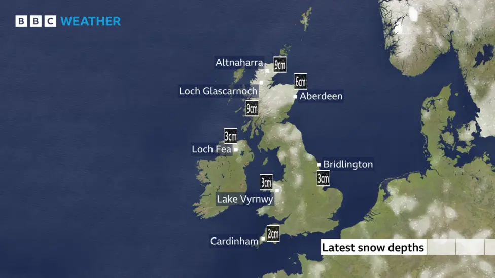
Snow blanketed locations across the country on Thursday, with Altnaharra in northern Scotland and Loch Glascarnoch in west Scotland recording 9 cm as of 11:00 GMT.
The snow and ice yellow warnings currently in place are:
Carmarthenshire, Ceredigion, Pembrokeshire and Swansea until 23:59
North-east England, south-west Scotland and Yorkshire & Humber until 23:59
Central and northern Scotland until 21:00
In these regions, expect 2 to 5cm of snow, even for low-lying areas, with perhaps as much as 10 to 20cm of snow for the highest ground in northern Scotland.
The yellow ice warnings due to come into force later on Thursday are:
South-west England from 18:00 to 11:00 on Friday
Eastern and south-east England from 18:00 Thursday until 11:00 Friday
North-east Scotland from 21:00 to 11:00 on Friday
North-east England, south-west Scotland and Yorkshire & Humber from 00:00 until 12:00 Friday
Western Wales from 00:00 to 11:00 on Friday
An amber warning for snow is in place until 21:00 Thursday and covers parts of north-east England and Yorkshire and the Humber.
(BBC article continues)
Icy conditions will sweep into more parts of the UK overnight, after snow and ice forced hundreds of schools to shut and closed roads in the worst-hit areas.
The Met Office has issued yellow warnings for ice in north-east Scotland, western Wales, south-west England, and along England's east coast, East Lothian and the Scottish Borders into Friday. Snow and ice warnings are already in place in some areas.
The North York Moors and parts of the Yorkshire Wolds are under an amber warning for snow and could see between 15-25 cm (6-10ins).
Thursday is expected to see the week's coldest night, with temperatures widely falling below zero and down to -12C in rural Scotland.
The UK Health Security Agency (UKHSA) has issued cold-health alerts for England until Saturday, saying there could be significant impacts to the elderly and people with health conditions.
Snow blanketed locations across the country on Thursday, with Altnaharra in northern Scotland and Loch Glascarnoch in west Scotland recording 9 cm as of 11:00 GMT.
The snow and ice yellow warnings currently in place are:
Carmarthenshire, Ceredigion, Pembrokeshire and Swansea until 23:59
North-east England, south-west Scotland and Yorkshire & Humber until 23:59
Central and northern Scotland until 21:00
In these regions, expect 2 to 5cm of snow, even for low-lying areas, with perhaps as much as 10 to 20cm of snow for the highest ground in northern Scotland.
The yellow ice warnings due to come into force later on Thursday are:
South-west England from 18:00 to 11:00 on Friday
Eastern and south-east England from 18:00 Thursday until 11:00 Friday
North-east Scotland from 21:00 to 11:00 on Friday
North-east England, south-west Scotland and Yorkshire & Humber from 00:00 until 12:00 Friday
Western Wales from 00:00 to 11:00 on Friday
An amber warning for snow is in place until 21:00 Thursday and covers parts of north-east England and Yorkshire and the Humber.
(BBC article continues)
| Re: Weather updates from across the UK, with implications for infrastructure - ongoing discussion, 2025 Posted by JohnM at 09:42, 20th November 2025 | |
First frost of the season here in Melksham.
The station sign didn't like it: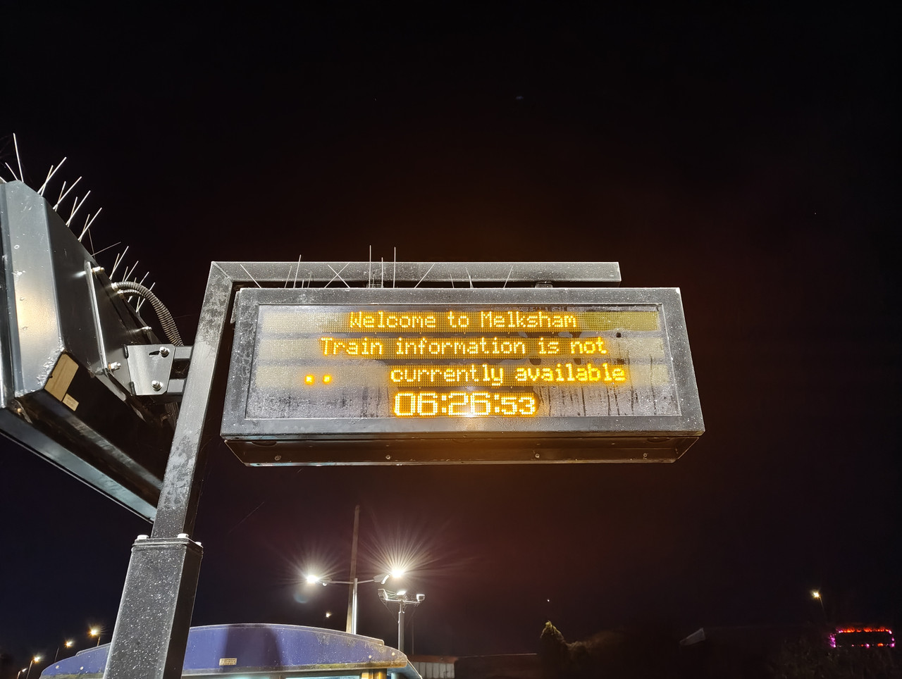
(National Rail app info was ok)
| Re: Weather updates from across the UK, with implications for infrastructure - ongoing discussion, 2025 Posted by grahame at 08:51, 20th November 2025 | |
Seemed to be quite a bit of wheel slip on the 06:46 Trowbridge-Bristol train this morning (-2C according to the Met office) - engine revs rise, train judders, revs drop, repeat. Didn't seem as bad once we got onto the main line.
First frost of the season here in Melksham. Lisa and I, Lulu and Lightning tucked up in our bedroom as our central heating boiler is being replaced this week and we have no heating.
| Re: Weather updates from across the UK, with implications for infrastructure - ongoing discussion, 2025 Posted by JohnM at 08:27, 20th November 2025 | |
Seemed to be quite a bit of wheel slip on the 06:46 Trowbridge-Bristol train this morning (-2C according to the Met office) - engine revs rise, train judders, revs drop, repeat. Didn't seem as bad once we got onto the main line.
| Re: Weather updates from across the UK, with implications for infrastructure - ongoing discussion, 2025 Posted by John D at 07:59, 18th November 2025 | |
A decent cold snap & the diesel fuel will wax up....
Busses use Adblu these days.Does that help reduce the wax up problem, and do diesel trains use the same/similar?
Adblu is an exhaust gas treatment added in exhaust system, so doesn't affect fuel delivery to pistons
There are chemical Pour Point depressants added to winter diesel to lower the ambient temperature where it starts to solidify. Years ago they use to add kerosene (aviation jet) to diesel in the winter to do same thing when winter flights were lower and jet was in excess in winter.
There are whole series of other additives that can be added if raw EN590 spec (Euro diesel) is not met when split at the refinery depending what spec it fails. Some would be rarely needed, but possibly a mix of additives was in one batch and different additives in another batch of fuel and when trains were topped up with fuel, they ended up together and some metals didn't really like it.
Not going to bore everyone with EN590 specs (can be googled) or the additives and their concentrations to correct the spec (and some are tiny proportions like one part in 10,000)
| Re: Weather updates from across the UK, with implications for infrastructure - ongoing discussion, 2025 Posted by GBM at 07:36, 18th November 2025 | |
A decent cold snap & the diesel fuel will wax up....
Busses use Adblu these days.Does that help reduce the wax up problem, and do diesel trains use the same/similar?
| Re: Weather updates from across the UK, with implications for infrastructure - ongoing discussion, 2025 Posted by ChrisB at 16:42, 17th November 2025 | |
A decent cold snap & the diesel fuel will wax up....
| Re: Weather updates from across the UK, with implications for infrastructure - ongoing discussion, 2025 Posted by TonyK at 16:25, 17th November 2025 | |
Last Wednesday's 1629 service to Axminster still hasn't left Barnstaple. It looks like bridge inspections won't happen until tomorrow at the earliest.
| Re: Weather updates from across the UK, with implications for infrastructure - ongoing discussion, 2025 Posted by Rob S at 12:17, 17th November 2025 | |
At the 2215-2300 window, remarkably quiet, as was the train
| Re: Weather updates from across the UK, with implications for infrastructure - ongoing discussion, 2025 Posted by Mark A at 12:03, 17th November 2025 | |
Useful to know from someone travelling, how this evolved, thanks - how busy was Paddington / your train by the way?
Mark
| Re: Weather updates from across the UK, with implications for infrastructure - ongoing discussion, 2025 Posted by Rob S at 11:30, 17th November 2025 | |
My experience on Friday was:
At about 2100 during the second interval of the thing I was in London to see, I checked the Railboard app to see what the trains were like as I was aware the BPW-SWI route had issues on my outward journey....the app said everything for PAD-SWI was cancelled for the rest of the night....after the show I headed to Tottenham Court Road for the Elizabeth Line and rechecked the app and it said the 2202 was running but delayed while everything else still cancelled. I got to Paddington 5 minutes after the 2202 eventually left (2211) but again, everything else still cancelled...then the 2228 changed from cancelled to 'On Time' (I had overheard the would be train manager telling a member of the public it would be running shortly before it appeared on the screens) and although it did go through the 2 mins late, 4 mins late, Delayed thing it did eventually leave at about 2300 on a planned route to Bristol TM via SWI,CPM,WSB,BTH.
| Re: Weather updates from across the UK, with implications for infrastructure - ongoing discussion, 2025 Posted by Timmer at 08:04, 15th November 2025 | |
Line between Bath and Chippenham now open meaning Bristol to London can run their booked route.
| Re: Weather updates from across the UK, with implications for infrastructure - ongoing discussion, 2025 Posted by Mark A at 08:02, 15th November 2025 | |
Friday's rain, and SWR ran everything Waterloo - Exeter on time. Not saying that to throw shade on GWR as yesterday's weather was a challenge, but as we all know there's something to be said for having two independent lines available - useful 365 days of the year, but on these occasions, particularly useful.
(Not dared look to see if the Exeters were all three carriage sets, hopefully not...)
Mark
| Re: Weather updates from across the UK, with implications for infrastructure - ongoing discussion, 2025 Posted by TaplowGreen at 07:32, 15th November 2025 | |
Going to make travel to Twickenham/Cardiff more difficult - International matches at both venues today.
| Re: Weather updates from across the UK, with implications for infrastructure - ongoing discussion, 2025 Posted by Timmer at 06:55, 15th November 2025 | |
When I saw the picture ChrisB posted last evening of the line at Corsham, I thought there’s no way that will be open this morning and it isn’t and wouldn’t be surprised if it’s all day if any line side equipment is damaged.
We’re travelling up to London today for a long weekend, fortunately not time sensitive and from Westbury. We go knowing that there will be diverted Bristol to London trains sharing the B&H tracks up to Reading on a very short notice timetable, so there may be a delay to our train.
After the amount of rain that fell yesterday, totally understandable and I commend GWR for the plan they’ve put together overnight to run trains as best they can around both flooded areas of track.
| Re: Weather updates from across the UK, with implications for infrastructure - ongoing discussion, 2025 Posted by grahame at 05:51, 15th November 2025 | |
15th November ... lines still closed due to flooding with GWR taking actions to divert / shorten / provide service where they can. Many are shortened / diverted - Swansea to London train becomes Swansea to Bristol (Temple Meads), London to Taunton becomes London to Chippenham, train from Bath to Swindon replaced by a bus which takes 80 minutes - three times longer than the train.
Thank you - GWR - you are at least doing something to help; I have no evidence to tell me if you are doing as much as you possibly could, or if you are working to a (tight?) replacement and diversion budget - and indeed what proportion of travellers will still be travelling in spite of the weather and disruption. Personally, discgression is the best part of valour and I am not carrying on with my plan to visit the Horniman museum, nor replacing it with anything else - though I may go shopping at Lidl. Partly put off by the weather and not wanting to add a wanted but needless passenger to what they have to cope with, but also put out by doubt as to how / when I would get home:
16:23 Westbury to Swindon due 17:05
17:35 Swindon to Westbury due 18:18
18:35 Westbury to Swindon due 19:17
19:44 Swindon to Westbury due 20:29
19:44 Swindon to Westbury due 20:29 will be cancelled.
This is due to a shortage of train crew.
Further Information
We're sorry for the disruption to your journey.
-
Road transport will be arranged and we'll update this message with more information.
Weather, sure, understood ... noting "shortage of train crew" so we'll employ bus or taxi crew instead. Rum system!
| Re: Weather updates from across the UK, with implications for infrastructure - ongoing discussion, 2025 Posted by Mark A at 22:42, 14th November 2025 | |
Ok, the line there is in the bottom of a valley, but that's a surprising sight, wondering if the aqueduct overtopped. Also wondering where the start of the 1:100 gradient down through Box Tunnel might be.
Mark
| Re: Weather updates from across the UK, with implications for infrastructure - ongoing discussion, 2025 Posted by grahame at 21:44, 14th November 2025 | |
The 20:12 Swindon-Westbury has reached Trowbridge on time.
I wonder if any passengers for Bath or Bristol were directed this way? - in spite of the cancellation of one service from Salisbury, there's a fair connection onto the Portsmouth-Cardiff.
I wonder if any passengers for Bath or Bristol were directed this way? - in spite of the cancellation of one service from Salisbury, there's a fair connection onto the Portsmouth-Cardiff.
It was an very unfortunate evening for a Swindon - Westbury (18:44) and a Westbury - Swindon (20:06) to be cancelled, wasn't it?
There is an ability to reverse trains at Bradford Junction, added for use during the closures for (non)electrification of Box tunnel. Why on earth is this not used?
| Re: Weather updates from across the UK, with implications for infrastructure - ongoing discussion, 2025 Posted by ChrisB at 21:14, 14th November 2025 | |
https://www.bbc.co.uk/news/articles/c4gw5xxej04o

Routes between London Paddington and Bristol and Swansea are closed due to flooding on the tracks, including here at Corsham near Bath
| Re: Weather updates from across the UK, with implications for infrastructure - ongoing discussion, 2025 Posted by Trowres at 20:59, 14th November 2025 | |
The 20:12 Swindon-Westbury has reached Trowbridge on time.
I wonder if any passengers for Bath or Bristol were directed this way? - in spite of the cancellation of one service from Salisbury, there's a fair connection onto the Portsmouth-Cardiff.
Meanwhile in the opposite direction there's a FO 9 coach IET running ECS Westbury-North Pole.
Some Paddington-Bristol services (in both directions) are being diverted via Newbury, although GWR Journeycheck is notably lacking in this bit of info (deliberate or not?)
| Re: Weather updates from across the UK, with implications for infrastructure - ongoing discussion, 2025 Posted by a-driver at 20:35, 14th November 2025 | |
The line between Chippenham and Bath Spa is under several feet of water.
| Re: Weather updates from across the UK, with implications for infrastructure - ongoing discussion, 2025 Posted by ChrisB at 20:32, 14th November 2025 | |
But is it better to try & run (& then fail) or to advise in advance & not trap anyone away from 'home'?
That's the conundrum, and a very difficult one - especially so in weather like today's where there may not be any available road transport should you try & run & find you can't.....
That's the conundrum, and a very difficult one - especially so in weather like today's where there may not be any available road transport should you try & run & find you can't.....
Hmmm......I bet they wish that they'd been told not to travel this morning.....
| Re: Weather updates from across the UK, with implications for infrastructure - ongoing discussion, 2025 Posted by grahame at 20:29, 14th November 2025 | |
Chaos at Swindon
Whats happening at the train station loads of police and it looks like they’re not letting anyone in
Trains are cancelled due to flooding and ppl fighting over taxis no system in place for passengers who are stuck getting home
Trains cancelled and no spare transport to shuttle ppl.
| Re: Weather updates from across the UK, with implications for infrastructure - ongoing discussion, 2025 Posted by grahame at 19:36, 14th November 2025 | |
DO NOT TRAVEL warnings now issued -
PAD - BRI
PAD - South Wales
Exeter & Barnstaple
HFD - WOS
PAD - BRI
PAD - South Wales
Exeter & Barnstaple
HFD - WOS
From my email
Dear Graham,
You may have seen that weather warnings have been issued for Storm Claudia with wind speeds of up to 80mph and heavy rain through the weekend. We have already experienced flooding on some sections of the network and we would urge all customers to check before travel by visiting:
www.gwr.com/check
Further travel information is also available through our live network updates page:
https://www.gwr.com/travel-information/travel-updates/live-network-updates
Due to current heavy flooding of the railway we are asking that customers do not travel on the following train lines:
London Paddington to Bristol Temple Meads via Swindon and Bath Spa
London Paddington to Swansea via Bristol Parkway and Cardiff
Exeter St Davids and Barnstaple
Hereford and Worcester Shrub Hill
On these routes we advise customers do not attempt to travel as we are unable to source any meaningful replacement road transport and cannot guarantee to be able to get you to your destination today. If you are able to make alternative travel arrangements we strongly suggest you do so. Customers with tickets for travel today will be able to use their ticket for travel up to and including Sunday 16 November. For refunds and compensation, including delay repay, please visit GWR compensation.
This graphic may be useful to share with your networks.
Any support you can provide communicating this would be much appreciated and please do not hesitate to get in touch should you have any queries.
Best wishes,
Olivia
Olivia Barlow | Deputy Head of Public Affairs | Great Western Railway
E: olivia.barlow@GWR.com
| Re: Weather updates from across the UK, with implications for infrastructure - ongoing discussion, 2025 Posted by ChrisB at 18:36, 14th November 2025 | |
DO NOT TRAVEL warnings now issued -
PAD - BRI
PAD - South Wales
Exeter & Barnstaple
HFD - WOS
| Re: Weather updates from across the UK, with implications for infrastructure - ongoing discussion, 2025 Posted by ChrisB at 16:02, 14th November 2025 | |
But is it better to try & run (& then fail) or to advise in advance & not trap anyone away from 'home'?
That's the conundrum, and a very difficult one - especially so in weather like today's where there may not be any available road transport should you try & run & find you can't.....
| Re: Weather updates from across the UK, with implications for infrastructure - ongoing discussion, 2025 Posted by Witham Bobby at 15:38, 14th November 2025 | |
It isn't - just cutting services short in order to stand a better chance of running to time
Unless you wanted to head to Alvechurch or Redditch in my example, or to Herefordshire from Great Malvern or points east.
I realise its a huge conundrum. But I'm pretty sure stopping the show when the weather turns adverse, but not impossibly so, is not the answer. People need a robust train service, not one that hides in a tunnel when the rain falls
| Re: Weather updates from across the UK, with implications for infrastructure - ongoing discussion, 2025 Posted by bobm at 14:53, 14th November 2025 | |
Over an inch of rain here since midnight - prior to today we had only had 14 inches all year!
| Re: Weather updates from across the UK, with implications for infrastructure - ongoing discussion, 2025 Posted by ChrisB at 12:26, 14th November 2025 | |
It isn't - just cutting services short in order to stand a better chance of running to time
| Re: Weather updates from across the UK, with implications for infrastructure - ongoing discussion, 2025 Posted by Witham Bobby at 12:12, 14th November 2025 | |
So basically just like any other November day in the past
We used to call it "weather". "Weather" would arrive without doom-laden advance announcements
Here in Worcestershire, the railway service between Longbridge and Redditch has been replaced today by a bus service, because of the weather. I can't see why a bus service would be any less prone to incident than would a railway service
| Re: Weather updates from across the UK, with implications for infrastructure - ongoing discussion, 2025 Posted by Phantom at 10:58, 14th November 2025 | |
So basically just like any other November day in the past
| Re: Weather updates from across the UK, with implications for infrastructure - ongoing discussion, 2025 Posted by ChrisB at 11:11, 13th November 2025 | |
From Sky News
Amber weather warning issued for parts of UK - as Storm Claudia brings heavy rain
An amber weather warning has been issued as Storm Claudia looks set to batter parts of the UK on Friday.
Flooding is likely with up to 80mm of rain expected, the Met Office said.
The warning is in place from noon until the end of the day, with it covering parts of Wales, the Midlands, the South West, South East and East of England.
| Re: Weather updates from across the UK, with implications for infrastructure - ongoing discussion, 2025 Posted by Chris from Nailsea at 22:43, 24th October 2025 | |
Those living in man-made underground bunkers - in Minehead, just for example - please note.
| Re: Weather updates from across the UK, with implications for infrastructure - ongoing discussion, 2025 Posted by TaplowGreen at 22:38, 24th October 2025 | |
From the BBC:
First snowfall of season possible for some as weekend cold snap arrives
Temperatures across the UK are set to fall this weekend, triggering the first snowfall of the season for some areas.
This coincides with the end of British Summer Time as the clocks go back with the weather reflecting the shift towards a more wintry feel.
Temperatures will be below average with strong, gusty winds making it feel especially cold and raw.
This change in weather is driven by the position of Storm Benjamin in the North Sea, drawing down a cold Arctic northerly airflow across the UK.
(BBC article continues)
Before people in Wiltshire and Somerset etc start panic buying heating equipment, ordering teams of huskies etc it's probably worth noting what the "BBC article continues" to say......
"If showers fall over high ground - mainly above 400m - there is the chance these will turn to snow.
This is most likely over the highest ground in Scotland where a few centimetres of snow accumulation are possible.
There may also be a touch of wintriness over the highest hills of northern England, Wales, and Northern Ireland"
......so we shouldn't need to prepare to he digging each other out of snowdrifts just yet.
Don’t panic, Captain Mainwaring.
| Re: Weather updates from across the UK, with implications for infrastructure - ongoing discussion, 2025 Posted by Chris from Nailsea at 21:48, 24th October 2025 | |
From the BBC:
First snowfall of season possible for some as weekend cold snap arrives
Temperatures across the UK are set to fall this weekend, triggering the first snowfall of the season for some areas.
This coincides with the end of British Summer Time as the clocks go back with the weather reflecting the shift towards a more wintry feel.
Temperatures will be below average with strong, gusty winds making it feel especially cold and raw.
This change in weather is driven by the position of Storm Benjamin in the North Sea, drawing down a cold Arctic northerly airflow across the UK.
(BBC article continues)
Temperatures across the UK are set to fall this weekend, triggering the first snowfall of the season for some areas.
This coincides with the end of British Summer Time as the clocks go back with the weather reflecting the shift towards a more wintry feel.
Temperatures will be below average with strong, gusty winds making it feel especially cold and raw.
This change in weather is driven by the position of Storm Benjamin in the North Sea, drawing down a cold Arctic northerly airflow across the UK.
(BBC article continues)
| Re: Weather updates from across the UK, with implications for infrastructure - ongoing discussion, 2025 Posted by grahame at 05:17, 24th October 2025 | |
Impressive, indeed ... I remember the wonders of the Cray supercomputer at ECMRWF (was it? - European Centre for Medium Range Weather Forecasting) in the south Reading / Bracknellish area which I visited for work when at Tektronix from 1976 to around 1982 - it was a wonder in those days to have any idea more than a few days ahead about what was coming, and a lot of work was being done to get the forecasts more accurate and further ahead. Hundreds of models were run, each with different input factors - taking the incoming data readings and adding "noise" at a low level within the measurements (e.g. a reading on 15.5 degrees may be distorted down to 15.45 and up to 15.55) and seeing what difference it made a week out in the forecast. "Monte Carlo method" as I recall. Ah - I reminisce ...
| Re: Weather updates from across the UK, with implications for infrastructure - ongoing discussion, 2025 Posted by stuving at 23:09, 23rd October 2025 | |
One aspect of forecasting that has changed a lot quite recently is how far ahead the models can predict major changes. If you looked for Benjamin when it was first mentioned, it was hard to see it, as it was just a group of little depressions milling about in the north Atlantic. Over the next couple of days these coalesced and deepened into a storm that set records for windspeed in some parts of France. I'm still impressed by that ability to project developments into the future so well that a detailed warning of a major storm can be issued.
| Re: Weather updates from across the UK, with implications for infrastructure - ongoing discussion, 2025 Posted by eightonedee at 22:47, 23rd October 2025 | |
My sympathy lies entirely with the Met Office. I’ve just come back from a few days away with 3 other friends of over 50 years standing, and we had the usual “accuracy of the weather forecast” discussion over our evening meal last night. As one of my friends, a senior nuclear engineer pointed out, weather forecasting involves one of the most difficult scientific disciplines, fluid dynamics. It annoys me that many journalists, who cannot get easily verified facts from recent history correct lazily devote pages and pages of text to ignorant waffle about the accuracy of weather forecasting.
It is inevitable that weather warnings, issued by scientists from at least four countries based on computer models developed over at least three decades, will not always be fully borne out by subsequent events. It is much better that they are issued than not, so that the many elements of our society that are directly affected by the weather (including transport operators, farmers, those responsible for structures that need to be prepared for adverse weather or responsible for the safe operation of works) can take the requisite precautions and make contingency plans, and keep those for whom they are responsible safe.
| Re: Weather updates from across the UK, with implications for infrastructure - ongoing discussion, 2025 Posted by Timmer at 17:54, 23rd October 2025 | |
When did the weather suddenly become end of days events?
Who would have thought we get wind and rain in October - watching GMB you would think the world was coming to an end
This is the problem with the Met Office issuing yellow warnings for every bit of wind and rain. It’s absolute click bait fodder for the media to produce apocalyptic type weather stories, even the BBC are doing it now.Who would have thought we get wind and rain in October - watching GMB you would think the world was coming to an end
Problem with this is, the public may soon tire of these warnings and click bait stories then don’t take them seriously when there really is severe weather.
| Re: Weather updates from across the UK, with implications for infrastructure - ongoing discussion, 2025 Posted by TaplowGreen at 14:13, 23rd October 2025 | |
When did the weather suddenly become end of days events?
Who would have thought we get wind and rain in October - watching GMB you would think the world was coming to an end
Who would have thought we get wind and rain in October - watching GMB you would think the world was coming to an end
.....and then, quite suddenly this morning, the dire warnings for nearly all of the country were removed and we have a typical breezy Autumn day, sun's just coming out here!
| Re: Weather updates from across the UK, with implications for infrastructure - ongoing discussion, 2025 Posted by Phantom at 10:28, 23rd October 2025 | |
When did the weather suddenly become end of days events?
Who would have thought we get wind and rain in October - watching GMB you would think the world was coming to an end
| Re: Weather updates from across the UK, with implications for infrastructure - ongoing discussion, 2025 Posted by Chris from Nailsea at 18:18, 22nd October 2025 | |
It is forecast to be into the mid 20s today in Ústí nad Labem.
Anyone heard from our friend recently?....Nearly 4 months gone now. Hope he's well.
I'll Czech ...
| Re: Weather updates from across the UK, with implications for infrastructure - ongoing discussion, 2025 Posted by ChrisB at 17:55, 22nd October 2025 | |
It is forecast to be into the mid 20s today in Ústí nad Labem.
Anyone heard from our friend recently?....Nearly 4 months gone now. Hope he's well.
| Re: Weather updates from across the UK, with implications for infrastructure - ongoing discussion, 2025 Posted by Chris from Nailsea at 13:00, 22nd October 2025 | |
From the BBC:
Storm Benjamin to bring gusty winds and flooding rain to UK on Thursday 23 October 2025
Storm Benjamin has been named by Météo France and will bring wet and windy weather to the United Kingdom on Thursday.
However, the most severe impacts will be felt across France, Belgium and the Netherlands.
In the UK heavy rain could lead to localised flooding and strong winds have the potential to bring travel disruption and minor damage.
The Met Office has issued yellow severe weather warnings for both the wind and rain.
Met Office yellow severe weather warnings issued for wind and rain on Thursday
Heavy rain will spread north-east across England and east Wales into Thursday.
The Met Office yellow warning for rain covers much of southern and eastern England from midnight on Wednesday night into Thursday, and through until 21:00 BST.
Rainfall totals by early Thursday morning could be widely 20-30mm (around 1in), and for some places 30-50mm (up to 2in).
There is a small chance a few places could exceed this, most likely over Devon, Cornwall up to the East Midlands, Lincolnshire, Humberside and East Anglia.
Localised flooding and some transport disruption is possible.
The wind will also strengthen for a time in the early hours across Kent and Sussex, with a Met Office yellow warning in force across eastern England from 03:00 Thursday until 23:59 BST.
While conditions could improve temporarily, the winds will pick up again during the afternoon.
There is an additional yellow warning from covering west Wales and south-west England from 06:00 until 15:00 BST.
Very strong north-westerly winds gusting to 45-55mph (70-90km/h) in both areas are possible, while locally 60mph (97km/h) on exposed coastal areas.
While there is still some uncertainty on the intensity of this weather system, the Met Office warns that there is potential for gusts up to 75mph (120km/h) for a small period of time later on Thursday morning down the North Sea coast.
These wind speeds have the potential to topple trees or their branches, cause travel disruption and even bring power cuts.
(BBC article continues)
| Re: Weather updates from across the UK, with implications for infrastructure - ongoing discussion, 2025 Posted by grahame at 17:44, 4th October 2025 | |
The "Melksham" line gained national recognition and was even featured in paintings, such as Arthur Wardle's "Three Greyhounds on the Valley"
or
https://www.etsy.com/uk/listing/1137142141/art-print-three-greyhounds-on-the-valley
At https://melkshamnews.com/melksham-times-past-21/ in our Melksham News, a local historian wrote a piece on these dogs last month.
Melksham Tom was one of the greatest stud dogs in the country during the 1930s and was the sire of more track winners than any other greyhound.
| Re: Weather updates from across the UK, with implications for infrastructure - ongoing discussion, 2025 Posted by JohnM at 17:14, 4th October 2025 | |
The "Melksham" line gained national recognition and was even featured in paintings, such as Arthur Wardle's "Three Greyhounds on the Valley"
or
https://www.etsy.com/uk/listing/1137142141/art-print-three-greyhounds-on-the-valley
| Re: Weather updates from across the UK, with implications for infrastructure - ongoing discussion, 2025 Posted by grahame at 15:54, 4th October 2025 | |
I am grateful for the colon : otherwise I would think North Somerset was a very strange name for a dog...... 

In Bosnia, according to her pet passport, she was called Darling. When she was 'rescued' to the UK, she was renamed Ginny. She still doesn't speak English, though.
On a depressing afternoon as trains are falling (or rather trees are) like bowling pins ... you two got me thinking about dogs that share names with places. I found a social media thread with pictures of dogs called Adelaide, Amararillo, Aspen, Denver, Elba, Kemi, Kona, Nancy, Salem and Victoria. In reality, a lot of those places are named after people so it's a real wan of corms. Here in Melksham ...
"Melksham Greyhounds" refers to a historically famous line of racing greyhounds bred in Melksham, Wiltshire, by Henry Sawtell. The most notable among them was Melksham Tom, who was a leading sire in the 1930s. The "Melksham" line gained national recognition and was even featured in paintings, such as Arthur Wardle's "Three Greyhounds on the Valley"
| Re: Weather updates from across the UK, with implications for infrastructure - ongoing discussion, 2025 Posted by Chris from Nailsea at 15:33, 4th October 2025 | |
I am grateful for the colon : otherwise I would think North Somerset was a very strange name for a dog......
In Bosnia, according to her pet passport, she was called Darling. When she was 'rescued' to the UK, she was renamed Ginny. She still doesn't speak English, though.
| Re: Weather updates from across the UK, with implications for infrastructure - ongoing discussion, 2025 Posted by grahame at 06:39, 4th October 2025 | |
I was planning to go to the Eastleigh Lakeside Railway today (4.10.2025) - however, plans aborted. The weather out there is awful, trains cancelled, etc - best try another time!! (Posting here to reach anyone who had picked up on the idea - probably a good day to stay at home!!)
| Re: Weather updates from across the UK, with implications for infrastructure - ongoing discussion, 2025 Posted by chuffed at 01:04, 4th October 2025 | |
I am grateful for the colon : otherwise I would think North Somerset was a very strange name for a dog......
| Re: Weather updates from across the UK, with implications for infrastructure - ongoing discussion, 2025 Posted by Chris from Nailsea at 21:55, 3rd October 2025 | |
It's rather wet and blustery, even down here in Nailsea, North Somerset: our dog just looked outside, through the patio door, and said (in Bosnian - she's a rescue from there) 'No, thanks.'
CfN.
| Re: Weather updates from across the UK, with implications for infrastructure - ongoing discussion, 2025 Posted by Chris from Nailsea at 15:33, 3rd October 2025 | |
Ahem.
| Re: Weather updates from across the UK, with implications for infrastructure - ongoing discussion, 2025 Posted by TaplowGreen at 15:32, 3rd October 2025 | |
So nothing really for our area above take care walking in exposed parts and wear a raincoat.
Not just a raincoat one would hope, or one really must take care with exposed parts!
| Re: Weather updates from across the UK, with implications for infrastructure - ongoing discussion, 2025 Posted by John D at 11:44, 3rd October 2025 | |
There are both rain and wind yellow warnings (be aware), but the amber warning (take action) is now north of Glasgow on Friday evening, and north of Inverness on Saturday.
So nothing really for our area above take care walking in exposed parts and wear a raincoat.
| Re: Weather updates from across the UK, with implications for infrastructure - ongoing discussion, 2025 Posted by grahame at 11:03, 3rd October 2025 | |
I do find it amusing how certain weather presenters (Tobin on GMB) make all these storms etc sound like end of world events, when in truth we have been experiencing them all our lives.
They act like it was an end of days moment approaching
Who would imagine high winds and rain in autumn
They act like it was an end of days moment approaching
Who would imagine high winds and rain in autumn
We seem to be getting more and more prone to these weather warnings - and I'm trying to work out whether it's because the weather is changing or the way of reporting it is changing.
I'm headed off - tomorrow - to the Eastleigh Lakeside Miniature Railway (nearest station Southampton Parkway) in spite of warnings in place for "up north".
| Re: Weather updates from across the UK, with implications for infrastructure - ongoing discussion, 2025 Posted by Phantom at 10:44, 3rd October 2025 | |
I do find it amusing how certain weather presenters (Tobin on GMB) make all these storms etc sound like end of world events, when in truth we have been experiencing them all our lives.
They act like it was an end of days moment approaching
Who would imagine high winds and rain in autumn
| Re: Weather updates from across the UK, with implications for infrastructure - ongoing discussion, 2025 Posted by Chris from Nailsea at 09:15, 3rd October 2025 | |
From the BBC:
Road and rail disruption as Storm Amy approaches
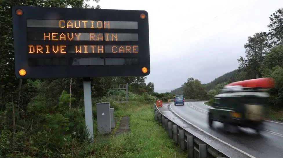
Travellers have been warned of disruption across Scotland later as Storm Amy is set to hit parts of the country with winds of up to 95mph.
An amber warning has been issued for large parts of north and west Scotland from 17:00 to 09:00 on Saturday.
Several ScotRail services and ferry journeys have been cancelled ahead of the storm's arrival.
A Met Office yellow warning for heavy rain has also been issued for Scotland and Northern Ireland, with a forecast for 20-30mm of rain in a six to nine hour period.
A wider yellow warning for winds to up to 60mph - and up to 70mph in exposed areas - has been issued for all of Scotland, Northern Ireland and large parts of north west England and Wales, from 15:00 to midnight on Saturday.
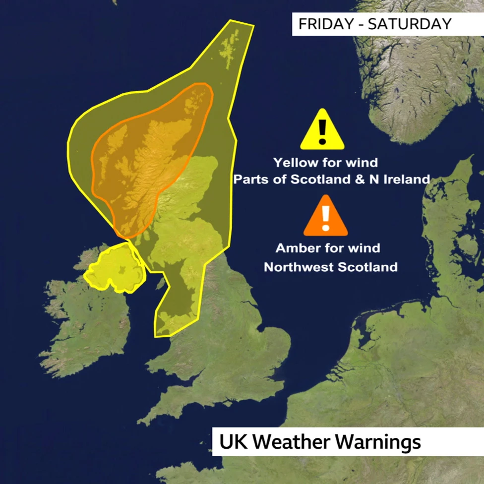
Scotland's transport secretary Fiona Hyslop asked people to check before they travel. She said: "We are urging people planning to travel on trains, ferries and flights to contact their operators to find out if their service is affected. Motorists will face difficult driving conditions, so it's vital people plan ahead if they have to travel to see if their route is impacted by the weather."
Expected transport disruption:
* Trains in the north of the country, including services between Perth-Inverness, Inverness-Aberdeen and Fort William-Crianlarich will be cancelled from 18:00.
* Speed restrictions will be introduced on all rail routes from 19:00.
* Traffic at the Rest and Be Thankful in Argyll has been diverted on to the Old Military Road. Traffic Scotland said it was monitoring conditions.
* Delays and cancellations to routes on CalMac's west coast ferry network. It asked passengers to check its website for updates.
Network Rail said its specialist weather team would be closely monitoring the storm's path and working with ScotRail to confirm the routes are most likely to be impacted.
David Ross, ScotRail chef operating officer, said many services in the north of the country would be severely impacted by the conditions. He also warned problems may continue into the weekend due to trains being out of position and potential debris on the line.
Mr Ross told BBC Radio's Good Morning Scotland: "We find that during disruption, it is very difficult to secure replacement buses late on in the day when we have severe weather and severe wind. Colleagues will be out inspecting the tracks, they'll be doing visual inspections from the air and if we find there are a significant number of trees down, that might take a bit longer to get services back up and running."
He told the programme that passengers with pre-booked tickets for Friday could also use them on Saturday and Sunday.
(BBC article continues)
Travellers have been warned of disruption across Scotland later as Storm Amy is set to hit parts of the country with winds of up to 95mph.
An amber warning has been issued for large parts of north and west Scotland from 17:00 to 09:00 on Saturday.
Several ScotRail services and ferry journeys have been cancelled ahead of the storm's arrival.
A Met Office yellow warning for heavy rain has also been issued for Scotland and Northern Ireland, with a forecast for 20-30mm of rain in a six to nine hour period.
A wider yellow warning for winds to up to 60mph - and up to 70mph in exposed areas - has been issued for all of Scotland, Northern Ireland and large parts of north west England and Wales, from 15:00 to midnight on Saturday.
Scotland's transport secretary Fiona Hyslop asked people to check before they travel. She said: "We are urging people planning to travel on trains, ferries and flights to contact their operators to find out if their service is affected. Motorists will face difficult driving conditions, so it's vital people plan ahead if they have to travel to see if their route is impacted by the weather."
Expected transport disruption:
* Trains in the north of the country, including services between Perth-Inverness, Inverness-Aberdeen and Fort William-Crianlarich will be cancelled from 18:00.
* Speed restrictions will be introduced on all rail routes from 19:00.
* Traffic at the Rest and Be Thankful in Argyll has been diverted on to the Old Military Road. Traffic Scotland said it was monitoring conditions.
* Delays and cancellations to routes on CalMac's west coast ferry network. It asked passengers to check its website for updates.
Network Rail said its specialist weather team would be closely monitoring the storm's path and working with ScotRail to confirm the routes are most likely to be impacted.
David Ross, ScotRail chef operating officer, said many services in the north of the country would be severely impacted by the conditions. He also warned problems may continue into the weekend due to trains being out of position and potential debris on the line.
Mr Ross told BBC Radio's Good Morning Scotland: "We find that during disruption, it is very difficult to secure replacement buses late on in the day when we have severe weather and severe wind. Colleagues will be out inspecting the tracks, they'll be doing visual inspections from the air and if we find there are a significant number of trees down, that might take a bit longer to get services back up and running."
He told the programme that passengers with pre-booked tickets for Friday could also use them on Saturday and Sunday.
(BBC article continues)
| Re: Weather updates from across the UK, with implications for infrastructure - ongoing discussion, 2025 Posted by Chris from Nailsea at 12:57, 1st October 2025 | |
From the BBC:
Storm Amy named with 80mph winds and severe weather warnings for the UK
The first named UK storm of the season - Storm Amy - is expected to hit the UK on Friday and Saturday, the Met Office has confirmed.
Amy will move to the north-west of the United Kingdom bringing gusts up to 80mph (129 km/h). Gales are expected widely with heavy rain.
Met Office yellow severe weather warnings for wind and rain have been issued from 12:00 Friday to 23:59 BST Saturday.
There is the possibility of damage and transport disruption into the weekend.
(BBC item continues)
| Re: Weather updates from across the UK, with implications for infrastructure - ongoing discussion, 2025 Posted by Chris from Nailsea at 23:13, 23rd September 2025 | |
| Re: Weather updates from across the UK, with implications for infrastructure - ongoing discussion, 2025 Posted by ChrisB at 20:21, 23rd September 2025 | |
No.
| Re: Weather updates from across the UK, with implications for infrastructure - ongoing discussion, 2025 Posted by Chris from Nailsea at 16:34, 23rd September 2025 | |
From the BBC:
Could Hurricane Gabrielle hit the UK this weekend?
Hurricane Gabrielle is only the second major hurricane of the Atlantic hurricane season, forming less than a week ago in the mid tropical Atlantic.
It rapidly intensified near Bermuda but after a sharp turn to the right it is now heading back across the Atlantic towards the Azores. Whilst Gabrielle will weaken as it travels over cooler waters, parts of western Europe are still likely to be hit by severe weather.
So far this season there have been more tropical storms and hurricanes in the east Pacific than the Atlantic basin. The Atlantic hurricane season has been quiet for multiple reasons but we are now in the peak period of hurricane activity.
Gabrielle strengthened on Monday to become a major hurricane near Bermuda. Early on Monday it was still a category 4 hurricane with sustained winds over 135mph (217km/h).
According to the National Hurricane Center the hurricane appears to have reached peak intensity. The eye of the hurricane is less distinct, probably as a result of vertical wind shear. Wind shear tends to weaken and ultimately rip hurricanes apart.
Gabrielle is forecast to be steered to the north of the sub-tropical ridge of high pressure then accelerate as it is picked up in a stronger westerly wind-flow. Increasing shear and cooler water should cause Gabrielle to weaken faster.
However, Gabrielle is still expected to be a hurricane as it approaches the Azores later on Thursday. Biggest impacts here could come from large waves forecast to be 5-6m high. From there the remnants of Hurricane Gabrielle will race on to mainland Europe.
(BBC article continues)
| Re: Weather updates from across the UK, with implications for infrastructure - ongoing discussion, 2025 Posted by Chris from Nailsea at 10:51, 15th September 2025 | |
From the BBC:
M48 Severn Bridge closed due to strong winds
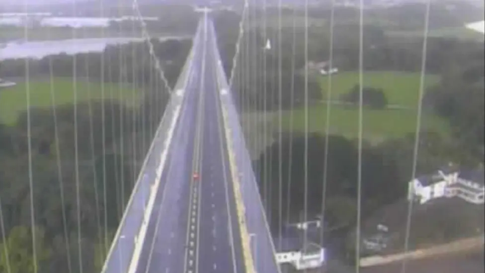
The Severn Bridge remains closed in both directions due to strong winds.
The M48 was shut on Sunday evening between J2 and the A466 Wye Valley Link Road at Chepstow and J1 A403 at Aust.
A Met Office yellow warning for wind has been issued across most of England and all of Wales and is valid until 18:00 BST Monday.
National Highways has advised drivers to follow the diversion in place via the M4 Prince of Wales Bridge and "take extra care" on the roads.
Winds gusts of 45mph to 55mph are expected widely inland, with gusts of 60mph to 70 mph possible along exposed coasts and hills.
| Re: Weather updates from across the UK, with implications for infrastructure - ongoing discussion, 2025 Posted by GBM at 13:57, 13th September 2025 | |
Seems there could be a 'deeper' low on Wednesday which could be worse that the Sunday/Monday one.
Heard on local radio from a local weather team (not the mainstream weather people).
| Re: Weather updates from across the UK, with implications for infrastructure - ongoing discussion, 2025 Posted by Chris from Nailsea at 18:36, 12th September 2025 | |
From the BBC:
Met Office extends UK weather warning as heavy rain and wind forecast for weekend
Millions of people will be under a yellow weather warning this weekend as strong winds and heavy rain are set to hit the UK.
There is likely to be some minor damage, as well as disruption to travel - especially to ferry services. Coastal routes, sea fronts and coastal communities could be affected by spray and/or large waves.
The Met Office warning is valid between 20:00 BST Sunday and 18:00 BST Monday for most of England and Wales.
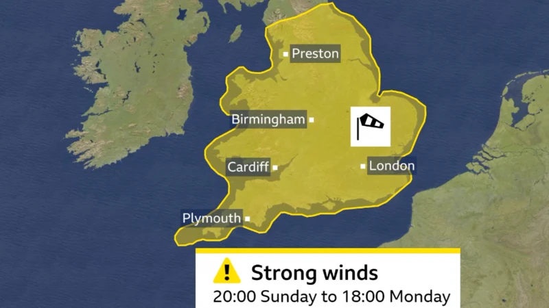
Ahead of these strong winds and heavy rain, there will continue to be lots of showers and some thunderstorms on Saturday. Sunday will start bright but heavy outbreaks of rain will spread to all areas, becoming increasingly windy with gales developing in the south and west of the UK.
Winds will gust to 50-60mph around coasts and hills. Winds this strong could bring down some tree branches and lead to some localised disruption. The Met Office's yellow warning for wind covers most of England and Wales.
Heavy rain is an additional hazard with 10-30mm falling widely with some western hills having around 70mm. There is a risk of surface water flooding and difficult driving conditions with the possibility of drains blocked by leaves, in part due to the false autumn leading to early leaf fall.
Areas of low pressure are named by either the Met Office, Met Eireann or KNMI - the Netherlands weather service - if the impacts are expected to be significant. The latest list of storm names were released in early September with Amy, Bram and Chandra being the first three named storms.
The area of low pressure bringing this unsettled weather is not thought - at the moment - to bring widespread impacts enough to be named by either Met Eireann or the Met Office.
Details can of course change so it would be worth staying tuned to the latest forecast.
(BBC article continues)
Millions of people will be under a yellow weather warning this weekend as strong winds and heavy rain are set to hit the UK.
There is likely to be some minor damage, as well as disruption to travel - especially to ferry services. Coastal routes, sea fronts and coastal communities could be affected by spray and/or large waves.
The Met Office warning is valid between 20:00 BST Sunday and 18:00 BST Monday for most of England and Wales.
Ahead of these strong winds and heavy rain, there will continue to be lots of showers and some thunderstorms on Saturday. Sunday will start bright but heavy outbreaks of rain will spread to all areas, becoming increasingly windy with gales developing in the south and west of the UK.
Winds will gust to 50-60mph around coasts and hills. Winds this strong could bring down some tree branches and lead to some localised disruption. The Met Office's yellow warning for wind covers most of England and Wales.
Heavy rain is an additional hazard with 10-30mm falling widely with some western hills having around 70mm. There is a risk of surface water flooding and difficult driving conditions with the possibility of drains blocked by leaves, in part due to the false autumn leading to early leaf fall.
Areas of low pressure are named by either the Met Office, Met Eireann or KNMI - the Netherlands weather service - if the impacts are expected to be significant. The latest list of storm names were released in early September with Amy, Bram and Chandra being the first three named storms.
The area of low pressure bringing this unsettled weather is not thought - at the moment - to bring widespread impacts enough to be named by either Met Eireann or the Met Office.
Details can of course change so it would be worth staying tuned to the latest forecast.
(BBC article continues)
| Re: Weather updates from across the UK, with implications for infrastructure - ongoing discussion, 2025 Posted by Chris from Nailsea at 20:57, 1st September 2025 | |
Funnily enough ... it's been generally broad sunshine, here in Nailsea.
| Re: Weather updates from across the UK, with implications for infrastructure - ongoing discussion, 2025 Posted by grahame at 20:24, 1st September 2025 | |
The last few days have been ... a relief.
| Re: Weather updates from across the UK, with implications for infrastructure - ongoing discussion, 2025 Posted by JayMac at 20:19, 1st September 2025 | |
I prefer the cooler temperatures we've had this past week. Reducing electricity costs not needing the air conditioner on in my bedroom.
As for rain, I drove through a biblical downpour on the M5 in Gloucestershire this morning. Standing water everywhere. Despite there being only moderate traffic we all slowed to around 30 mph. No one risked driving any faster.
| Re: Weather updates from across the UK, with implications for infrastructure - ongoing discussion, 2025 Posted by Chris from Nailsea at 20:08, 1st September 2025 | |
From BBC Weather:
Summer 2025 confirmed as UK's hottest on record
The Met Office has confirmed that summer 2025 is officially the hottest on record for the United Kingdom.
Provisional statistics show that the mean temperature across the country - which includes overnight lows as well as daytime highs - was 16.10C (60.98F).
This is 1.51C (2.72F) above the long-term average and well ahead of 2018, the previous warmest summer, which had a mean temperature of 15.76C (60.37F).
It is in line with evidence that summers are getting hotter and drier because of climate change.
Met Office climate scientists have found that a summer as hot or hotter than 2025 is now 70 times more likely than it would have been in a "natural" climate, with no human-induced greenhouse gas emissions.
2025 has pushed the famous summer of 1976 out of the UK top-five, meaning the five hottest summers have all occurred since 2000.
The highest temperature of the summer was 35.8C (96.4F), recorded at Faversham, Kent on 1 July.
This may seem relatively modest compared with some of the exceptional highs of previous years, including the record-breaking 40.3C (104.5F) recorded in July 2022.
However what is notable about this summer is how long-lasting and widespread the heat has been - with temperatures widely meeting heatwave criteria on four separate occasions.
The heat started early with a June heatwave which brought highs above 33C (91F) for the summer solstice.
The mercury then climbed again later in the month with Wimbledon seeing its hottest start to the tournament on record.
A brief cooler spell in early July was followed by a third heatwave which brought Scotland, Northern Ireland and Wales their hottest weather of the year.
A fourth heatwave in August brought temperatures of 33.4C (92.1F) in parts of England, while 31.6C (88.9F) at Charterhall in the Borders, was Scotland's highest August temperature since 2003.
The warmth was often accompanied by blue skies with sunshine amounts above average across most of the UK.
(BBC Weather article continues)
Personally, I enjoy the warmer weather, but I do worry about my daughter's generation. I am age 66, she is age 28. There are a lot more 'global warming' implications in there.

| Re: Weather updates from across the UK, with implications for infrastructure - ongoing discussion, 2025 Posted by Mark A at 10:56, 15th August 2025 | |
Ugh. Just about the anniversary of the downpour near Stonehaven that washed debris from a drain installation onto the track with fatal consequences.
Mark
| Re: Weather updates from across the UK, with implications for infrastructure - ongoing discussion, 2025 Posted by Chris from Nailsea at 23:01, 14th August 2025 | |
From the BBC:
Floods, mudslides and giant hailstones hit parts of Scotland
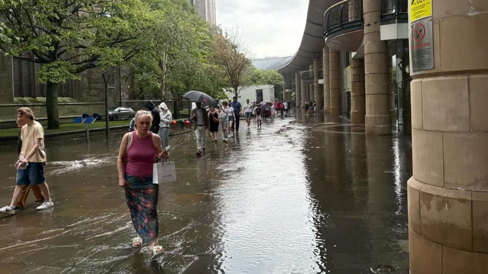
A Dundee shopping centre was evacuated and an Aberdeenshire road has been closed by a mudslide after some unseasonal weather hit parts of Scotland.
Shoppers were told to leave the Overgate centre after water started pouring down ramps to the front of the building at about 16:15.
Large hailstones, some the size of £1 coins, fell in a 20-minute burst over the city, with some roads also flooded in the city centre.
Part of Aberdeenshire were also hit by powerful hailstorms, and a section of the A97 has been closed following a mudslide.
Footage posted on social media showed winter-like scenes in Aberdeenshire as hail storms left the the ground looking as if snow had fallen.
Police Scotland said the A97 Dinnet to Glenbuchat road was closed in both directions between Logie Coldstone and the junction with the B9119, Tarland Road, following a mudslide.
Drivers have been advised to avoid the area.
The downpour in Dundee started shortly before 16:00 and caused drains to overflow, forcing the drain covers onto the road in the Nethergate.
Cars were seen navigating the flood water on West Marketgait, close to the city's sheriff court.
Water pooled on tracks at Dundee Railway Station, but trains were unaffected.
Streets in the Nethergate beside the city's V&A Museum were also affected by flooding.
My highlighting. CfN.
| Re: Weather updates from across the UK, with implications for infrastructure - ongoing discussion, 2025 Posted by Chris from Nailsea at 14:19, 11th August 2025 | |
From the BBC:
Amber health alerts as heatwave temperatures set to hit 34c

Temperatures have been rising and will continue to do so with the fourth heatwave of the summer on the way for some.
The UK Health Security Agency has issued heat health alerts, for all of England - beginning on Tuesday morning and lasting until Wednesday.
On Monday, five areas of England had their health alerts upgraded from yellow to amber - meaning there could be travel disruption or increased demand on health services.
The hottest weather will be focused in central and southern England, where temperatures are expected to exceed the official heatwave criteria for at least three consecutive days with a peak of 34C (93F) possible on Tuesday.
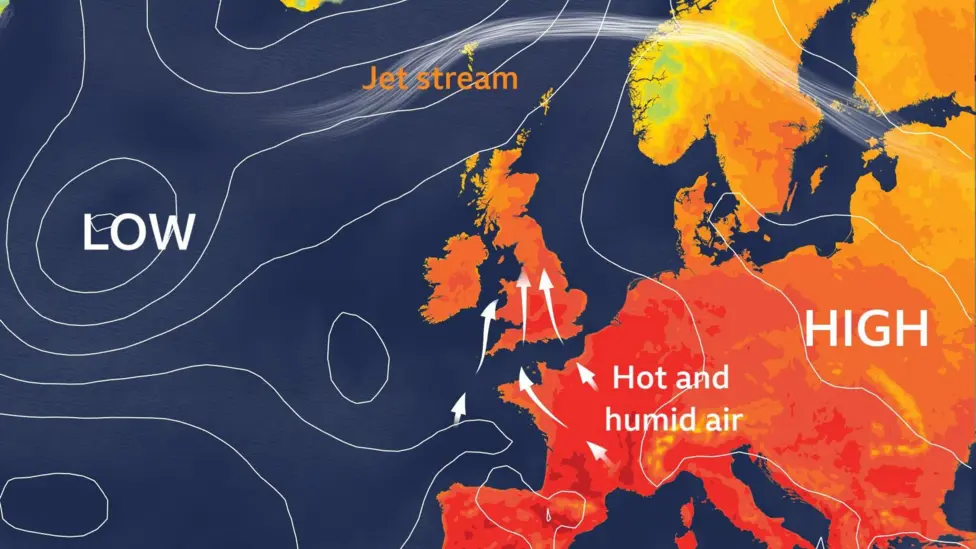
As high pressure dominates across central Europe, extreme heat has already been building in paces including Spain, Portugal and France. The French city of Nimes recorded its highest ever August temperature on Sunday of 41.8C (107F). Red extreme heat warnings in south-west France remain in place through Monday and Tuesday. Some of that hot and humid air to our south will gradually spread north across the UK over the coming days.
On Monday, many parts of England and Wales will see temperatures in the mid to high 20s. The London area is forecast to be around 30C whilst Scotland and Northern Ireland will remain a little cooler with highs in the low 20s.
By Tuesday, the warmth will become more intense and widespread as the heatwave reaches its peak. Most of the UK will record temperatures between 24 and 30C, with the hottest conditions again focused on London and the Midlands which could reach 34C (93F). It's not currently expected to beat the UK's hottest day of 2025, which so far stands at 35.8C (96F) recorded on 1st July in Faversham, Kent.
Wednesday will be another hot day for many, but probably not quite as hot as Tuesday, due to a small shift in wind direction. Heatwave criteria is likely to hold on across central and eastern parts of England, east Wales and eastern Scotland. Yellow heat health alerts will be in place for the whole of England from Tuesday morning until Wednesday evening, with amber alerts in place for London, the South East, East of England, East Midlands and West Midlands. As well as heat by day, the nights will also feel hot and humid for the first half of the week. There is a chance of a tropical night or two in southern England, where temperatures don't fall below 20C all night.
By Thursday and Friday, whilst most places will see temperatures in the low to mid 20s, we could record further heatwave days in southern England.
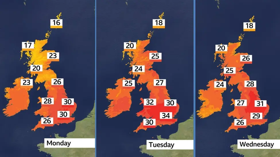
(BBC article continues)
Temperatures have been rising and will continue to do so with the fourth heatwave of the summer on the way for some.
The UK Health Security Agency has issued heat health alerts, for all of England - beginning on Tuesday morning and lasting until Wednesday.
On Monday, five areas of England had their health alerts upgraded from yellow to amber - meaning there could be travel disruption or increased demand on health services.
The hottest weather will be focused in central and southern England, where temperatures are expected to exceed the official heatwave criteria for at least three consecutive days with a peak of 34C (93F) possible on Tuesday.
As high pressure dominates across central Europe, extreme heat has already been building in paces including Spain, Portugal and France. The French city of Nimes recorded its highest ever August temperature on Sunday of 41.8C (107F). Red extreme heat warnings in south-west France remain in place through Monday and Tuesday. Some of that hot and humid air to our south will gradually spread north across the UK over the coming days.
On Monday, many parts of England and Wales will see temperatures in the mid to high 20s. The London area is forecast to be around 30C whilst Scotland and Northern Ireland will remain a little cooler with highs in the low 20s.
By Tuesday, the warmth will become more intense and widespread as the heatwave reaches its peak. Most of the UK will record temperatures between 24 and 30C, with the hottest conditions again focused on London and the Midlands which could reach 34C (93F). It's not currently expected to beat the UK's hottest day of 2025, which so far stands at 35.8C (96F) recorded on 1st July in Faversham, Kent.
Wednesday will be another hot day for many, but probably not quite as hot as Tuesday, due to a small shift in wind direction. Heatwave criteria is likely to hold on across central and eastern parts of England, east Wales and eastern Scotland. Yellow heat health alerts will be in place for the whole of England from Tuesday morning until Wednesday evening, with amber alerts in place for London, the South East, East of England, East Midlands and West Midlands. As well as heat by day, the nights will also feel hot and humid for the first half of the week. There is a chance of a tropical night or two in southern England, where temperatures don't fall below 20C all night.
By Thursday and Friday, whilst most places will see temperatures in the low to mid 20s, we could record further heatwave days in southern England.
(BBC article continues)
| Re: Weather updates from across the UK, with implications for infrastructure - ongoing discussion, 2025 Posted by Chris from Nailsea at 11:27, 3rd August 2025 | |
From the BBC:
Amber warning issued ahead of Storm Floris
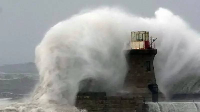
Weather warnings have been upgraded to amber for most of Scotland as Storm Floris bears down on the UK.
The warning lasts from 10:00 BST on Monday through to 22:00 and warns of danger to life as damage to buildings and trees due to storm conditions is expected.
There is also a yellow warning across northern England and Northern Ireland from 06:00 BST on Monday through to midnight.
Storm Floris is the sixth named storm of the 2024/25 season, and the first since January.
The storm is yet to develop but there will be a rapid drop in pressure as the system nears our shores on Sunday night.
It expected to bring "unusually strong" west or north-westerly winds to much of Scotland.
The amber warning covers a wide area as far south as the country's central belt - including Glasgow and Edinburgh and also the Highlands.
Gusts of 50 to 70mph are expected, even inland. Exposed coasts, hills and bridges could see gusts of 80 to 90mph, while some models have even suggested 100mph gusts which were last seen during Storm Éowyn in January.
The worst of the winds will be in the western coastal areas of the warning zone between late morning and early afternoon.
As the storm spirals away by late afternoon and early evening the strongest winds will move further eastwards to coastal areas of Aberdeenshire.
Trees are in full leaf at this time of year and are more likely to be toppled with branches broken off than during winter when the wind can whistle through them unimpeded.
Power disruption is also possible while heavy rain and flooding could be an additional hazard.
Named storms in August are not that rare.
Last year, Storm Lilian struck the UK on 23 August just before the bank holiday weekend, closing stages at the Leeds Festival and cancelling Heathrow flights.
In 2023, Storm Antoni brought wet and very windy weather to south Wales and south-west England affecting events such as Brighton and Plymouth Pride. Less than two weeks later Storm Betty brought further disruption.
In 2020 there were also two August storms - Ellen and Francis - that the Met Office describes as "two of the most notable August storms in the last 50 years."
These two storms brought wind gusts of 79mph and 81mph respectively with transport disruption, coastal flooding and power cuts.
The storm follows the UK's fifth warmest July on record, according to provisional figures from the Met Office.
All four UK nations recorded one of their 10 warmest Julys, and July was the sixth consecutive month of above-average mean temperatures for the UK, the Met Office said.
The first day of the month brought the highest temperature of the year so far, with 35.8C in Faversham, Kent.
| Re: Weather updates from across the UK, with implications for infrastructure - ongoing discussion, 2025 Posted by Chris from Nailsea at 20:15, 1st August 2025 | |
From the BBC:
Storm Floris to bring 'unseasonably disruptive' rain and wind to UK
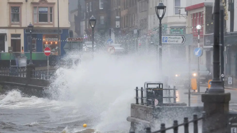
Storm Floris has been named by the Met Office and will hit the UK on Monday, bringing strong winds and heavy rain.
It is the sixth named storm this season and the first since January.
Current forecasts show the centre of Floris travelling across the northern half of the UK, with the strongest and most disruptive winds on the southern and western edge of the area of low pressure.
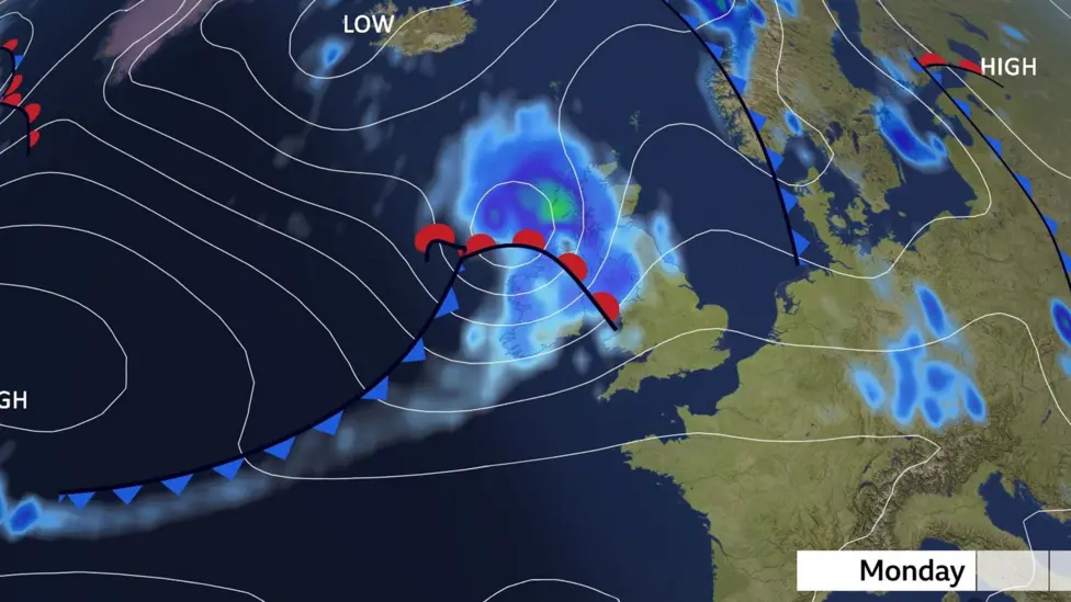
Some forecasts show the potential for wind gusts of between 60 and 70mph in places, particularly for coasts and hills in the north during the day on Monday. Exposed coastal areas of Scotland could see gusts of up to 85mph.
Across the warning area, many inland areas are likely to see gusts of 40-50mph.
Even for areas in the south there could be gusts of 40-45mph.
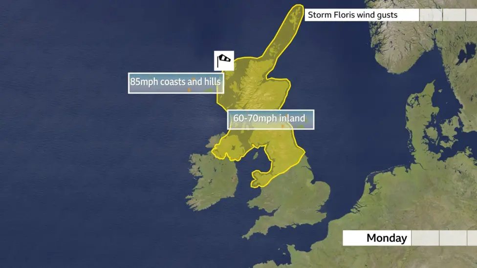
The area of cloud and rain that may bring some of us the stormier spell was still only a band of heavy showers near the Great Lakes in the US on Thursday morning.
As this heads out into the Atlantic it will get picked up by an active jet stream and will develop into a storm with a huge drop in pressure as it nears our shores.
It is worth noting that Monday is still a number of days away and the exact track of the low pressure system will be crucial to which areas may be worst affected and so it is worth staying across the BBC Weather forecast over the coming days to keep across the latest.
If the winds do reach their forecast strength then they are likely to have an impact on travel.
At this time of year trees are in full leaf and are more likely to be toppled with branches broken off than during the winter when the wind can whistle through them unimpeded.
Many temporary summer structures including tents could be damaged.
Power disruption and some damage could also be possible while heavy rain and flooding could be an additional hazard in places.
(BBC article continues)
Storm Floris has been named by the Met Office and will hit the UK on Monday, bringing strong winds and heavy rain.
It is the sixth named storm this season and the first since January.
Current forecasts show the centre of Floris travelling across the northern half of the UK, with the strongest and most disruptive winds on the southern and western edge of the area of low pressure.
Some forecasts show the potential for wind gusts of between 60 and 70mph in places, particularly for coasts and hills in the north during the day on Monday. Exposed coastal areas of Scotland could see gusts of up to 85mph.
Across the warning area, many inland areas are likely to see gusts of 40-50mph.
Even for areas in the south there could be gusts of 40-45mph.
The area of cloud and rain that may bring some of us the stormier spell was still only a band of heavy showers near the Great Lakes in the US on Thursday morning.
As this heads out into the Atlantic it will get picked up by an active jet stream and will develop into a storm with a huge drop in pressure as it nears our shores.
It is worth noting that Monday is still a number of days away and the exact track of the low pressure system will be crucial to which areas may be worst affected and so it is worth staying across the BBC Weather forecast over the coming days to keep across the latest.
If the winds do reach their forecast strength then they are likely to have an impact on travel.
At this time of year trees are in full leaf and are more likely to be toppled with branches broken off than during the winter when the wind can whistle through them unimpeded.
Many temporary summer structures including tents could be damaged.
Power disruption and some damage could also be possible while heavy rain and flooding could be an additional hazard in places.
(BBC article continues)
| Re: Weather updates from across the UK, with implications for infrastructure - ongoing discussion, 2025 Posted by ChrisB at 18:38, 30th July 2025 | |
Monday's weather looking particularly atrocious....
| Re: Weather updates from across the UK, with implications for infrastructure - ongoing discussion, 2025 Posted by Chris from Nailsea at 18:32, 30th July 2025 | |
From the BBC:
BBC reunites with Met Office for weather forecasts
The BBC is to reunite with the Met Office for its weather forecasts and climate updates, eight years after the relationship between the two organisations ended.
The new partnership, announced on Wednesday, is aimed at delivering "the most trusted and accurate weather service to everyone in the UK", the corporation said.
Since September 2017, data for the BBC's TV, radio and online forecasts has been provided by the Dutch MeteoGroup which was subsequently acquired by the US weather services company DTN.
BBC director general Tim Davie said the weather is "the UK's favourite conversation" and "hugely important to all our lives and all our audiences across the world". He added: "The BBC's world-renowned journalism will be working together with the Met Office's weather and climate intelligence to turn science into stories and help everyone in the UK to make informed decisions about the weather. There has never been more need for trusted and impartial information to help people understand today's weather."
No new jobs, or job cuts, have been announced as part of the deal.
BBC News understands it is not a commercial relationship involving procurement, but an agreement between the two organisations in the interests of public service.
Penny Endersby, CEO of the Met Office said on Wednesday: "As the UK's national weather service, we are excited to be back working closely with the BBC again. Together we can reach even more people with essential weather information, helping them to plan their days, stay safe when it matters and keep well-informed in our changing climate."
In 2022, a national emergency was declared in the UK after a red extreme heat warning was issued for the first time, as temperatures hit 40C (104F).
The Met Office is the UK's national weather service and a world-leading centre for climate science.
The BBC's weather forecasts will continue to come from DTN for the time being and an update on the new partnership with the Met Office is expected "later this year".
The corporation added in a statement it wanted to "help more people stay safe, thrive and understand the wonder of weather".
| Re: Weather updates from across the UK, with implications for infrastructure - ongoing discussion, 2025 Posted by TaplowGreen at 13:58, 19th July 2025 | |
Thankyou.....you're a little ray of sunshine!
| Re: Weather updates from across the UK, with implications for infrastructure - ongoing discussion, 2025 Posted by Chris from Nailsea at 13:39, 19th July 2025 | |
An update, from the BBC:
More yellow rain and thunderstorm alerts bring threat of flash floods
An amber weather warning did not produce the intense rain and flash flooding that was feared, but more unsettled weather is on the way for much of the UK.
All four nations of the UK are blanketed by yellow rain and thunderstorm warnings for the rest of Saturday, with the Met Office saying this could bring flash flooding, power cuts and disruption to travel.
Further yellow alerts for heavy rain and some thunderstorms cover Scotland and south west England on Sunday - with a new yellow thunderstorm alert extended across much of England on Monday.
But flash flooding forecast for London and south-east England on Saturday morning "thankfully didn't occur", BBC Weather's Simon King said.
The wet weekend comes after a third heatwave of the year that parched swathes of the UK and led to several hosepipe bans being declared.
The recent warm spell has made flooding more likely and severe as the dry ground is unable to absorb as much water.
Earlier, the Met Office warned that London, Cambridge and the south coast could see a month's worth of rainfall - between 20 and 40mm (0.8in to 1.6in) in an hour, but in most areas this was not as bad as feared.
BBC Weather's Simon King said "the really intense downpours didn't occur", with Charlwood in Surrey seeing the most rain with 23mm in an hour on Saturday morning, and 14mm in an hour in Kenley, Croydon.
"The worst of the intense rain and frequent thunderstorms expected in south-east England this morning didn't quite develop as forecast," he said. "Therefore the anticipated flash flooding in the Met Office amber warning thankfully didn't occur.
"However, with yellow warnings still in force quite widely, there is still a chance of more localised and isolated impacts from thunderstorms."
This includes "large downpours bringing the risk of a bit of flash flooding and big puddles that could cause some travel disruption", he added.
The yellow thunderstorm warning in place for Saturday afternoon covers all of England except for the south west.
These additional warnings are in place:
Yellow alerts indicate a "slight chance" of power cuts, flooding for roads and businesses and some delays and cancellations to train and bus services, according to the Met Office.
An amber weather warning did not produce the intense rain and flash flooding that was feared, but more unsettled weather is on the way for much of the UK.
All four nations of the UK are blanketed by yellow rain and thunderstorm warnings for the rest of Saturday, with the Met Office saying this could bring flash flooding, power cuts and disruption to travel.
Further yellow alerts for heavy rain and some thunderstorms cover Scotland and south west England on Sunday - with a new yellow thunderstorm alert extended across much of England on Monday.
But flash flooding forecast for London and south-east England on Saturday morning "thankfully didn't occur", BBC Weather's Simon King said.
The wet weekend comes after a third heatwave of the year that parched swathes of the UK and led to several hosepipe bans being declared.
The recent warm spell has made flooding more likely and severe as the dry ground is unable to absorb as much water.
Earlier, the Met Office warned that London, Cambridge and the south coast could see a month's worth of rainfall - between 20 and 40mm (0.8in to 1.6in) in an hour, but in most areas this was not as bad as feared.
BBC Weather's Simon King said "the really intense downpours didn't occur", with Charlwood in Surrey seeing the most rain with 23mm in an hour on Saturday morning, and 14mm in an hour in Kenley, Croydon.
"The worst of the intense rain and frequent thunderstorms expected in south-east England this morning didn't quite develop as forecast," he said. "Therefore the anticipated flash flooding in the Met Office amber warning thankfully didn't occur.
"However, with yellow warnings still in force quite widely, there is still a chance of more localised and isolated impacts from thunderstorms."
This includes "large downpours bringing the risk of a bit of flash flooding and big puddles that could cause some travel disruption", he added.
The yellow thunderstorm warning in place for Saturday afternoon covers all of England except for the south west.
These additional warnings are in place:
- * Yellow warning of rain for all of Devon, Cornwall and south Wales, with a risk of localised flooding, thunderstorms and transport disruption, from 18:00 on Saturday until 21:00 on Sunday
* Yellow warning of thunderstorms for the western half of Northern Ireland from 12:00 until 18:00 on Saturday
* Yellow warning of rain covering all of Scotland, apart from the Hebrides and some areas of the western coast, from midday on Saturday until midday on Sunday
* On Monday, from 11:00 to 21:00, a yellow warning for heavy showers and thunderstorms for all of central, southern and northern England apart from the south west - as well as all of central and southern Scotland.
Yellow alerts indicate a "slight chance" of power cuts, flooding for roads and businesses and some delays and cancellations to train and bus services, according to the Met Office.
| Re: Weather updates from across the UK, with implications for infrastructure - ongoing discussion, 2025 Posted by Chris from Nailsea at 11:49, 19th July 2025 | |
From the BBC:
Amber weather warning over but flash flood threat remains
Yellow weather warnings for thunderstorms and heavy rain are in place for much of the UK, bringing potential for flash flooding.
Most of England falls under the alert which runs until 21:00 BST and may cause disruption to travel, fast-flowing water and power cuts, the Met Office says.
A separate yellow rain warning covers eastern Scotland from the Borders up to Aberdeen, running from 16:00 on Saturday until noon on Sunday.
It follows the agency issuing a more severe amber thunderstorm warning for London and south-east England which ended at 11:00 on Saturday, though the "torrential downpours" forecast were not as bad as feared.
The wet weekend comes after a third heatwave of the year that parched swathes of the UK and led to several hosepipe bans being declared.
The recent warm spell has made flooding more likely and severe as the dry ground is unable to absorb as much water.
While the more severe warning is now over, the yellow thunderstorm warning in place for Saturday afternoon covers all of England except for the south west.
All of Cornwall and much of Devon fall under a separate yellow warning for rain from midday on Sunday until the early hours of Monday.
This is alongside the rain warning in eastern and central Scotland, which runs overnight on Saturday.
Wales and Northern Ireland have escaped the alerts.
Yellow alerts indicate a "slight chance" of power cuts, flooding for roads and businesses and some delays and cancellations to train and bus services, according to the Met Office.
Thunderstorms develop when warm and humid air exists below much colder air in the atmosphere. This destabilises the air, allowing clouds to form and produce heavy rain - and storms.
They have developed over northern France but they will be allowed to "grow" as they move north over the eastern half of the UK on Saturday.
(BBC article continues)
| Re: Weather updates from across the UK, with implications for infrastructure - ongoing discussion, 2025 Posted by TaplowGreen at 16:25, 18th July 2025 | |
Not BBQ weather this weekend!
| Re: Weather updates from across the UK, with implications for infrastructure - ongoing discussion, 2025 Posted by Chris from Nailsea at 13:09, 18th July 2025 | |
From the BBC:
Amber weather warning issued as thunderstorms and flooding to cause significant disruption
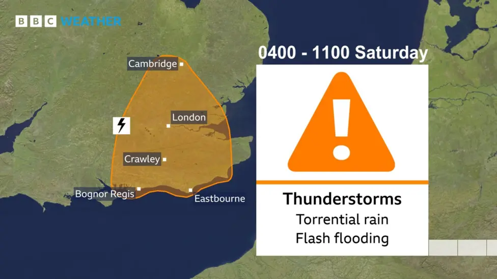
Amber thunderstorm warnings have been issued for Saturday morning by the Met Office for parts south-east and eastern England.
Rain will be torrential with 20-40mm (about an inch) in an hour but as much as 70-100mm (up to 4 inches) in a few hours. This is over a month's worth falling in places, leading to areas of flash flooding and very significant disruption.
The amber warnings come into force from 0400 to 1100 on Saturday with a raft of yellow warnings also in force across a wide area of England and Scotland.
Frequent lightning, large hail and gusty winds are additional hazards that would bring transport disruption.
The thunderstorms and heavy rain are likely to roll into central southern England, south-east England and the Midlands on Friday night before moving to northern England and Scotland by Saturday.
This area of rain could become slow-moving across northern Scotland during Sunday, with a threat of some flash flooding.
Low pressure looks set to take hold of the weather across the UK on Sunday and Monday with further widespread showers and thunderstorms likely.
(BBC article continues)
| Re: Weather updates from across the UK, with implications for infrastructure - ongoing discussion, 2025 Posted by Chris from Nailsea at 23:02, 27th June 2025 | |
From the BBC:
Health alerts come into force ahead of second heatwave
Heat health alerts have come into force across most of England as the country braces for a second summer heatwave.
An amber alert covers the East Midlands, south-east, south-west, east and London - meaning various health services and the whole population could be affected by the heat, according to the UK Health Security Agency (UKHSA).
In Yorkshire and the Humber, as well as the West Midlands, less serious yellow alerts apply, meaning that the elderly and vulnerable could be affected.
Temperatures are forecast to rise into the 30s over the weekend, coniciding with Glastonbury Festival, before reaching a new high for the year on Monday, when the Wimbledon tennis championship begins.
Monday could be the hottest day of the year so far with a temperature of 34C, possibly 35C in London towards the Cambridgeshire area, according to BBC Weather. The Met Office says London could reach 34-35C.
That would make Monday the hottest ever start to Wimbledon, exceeding the previous opening-day record of 29.3C in 2001 - although players and spectators can expect more comfortable temperatures in the 20s by the middle of next week. The hottest day during Wimbledon as a whole was on 1 July 2015 when 35.7C was recorded.
Temperatures will remain in the mid to high 20s for the 200,000 festival-goers descending on Glastonbury in Somerset this weekend, with a potential peak of 28C on Sunday.
Mark Savage, the BBC's music correspondent at the festival, said shorts, sun hats, bikini tops and bottled water were the order of the day on Friday. He observed no heat-related health issues - other than the occasional red nose and a few very sleepy children.
Although there was little shade at the Pyramid Stage and temperatures were set to soar higher over the weekend, there was plenty of free water and sun cream around the site.
Conditions are expected to remain dry with sunny spells - free of the mud baths of years past - but warm nights could make things for uncomfortable for campers.
Elsewhere in Britain, dry and sunny spells are forecast, with temperatures in the low to mid 20s this weekend. By Monday, Cardiff could match the 30C highs expected across large parts of England.
(Article continues)
| Re: Weather updates from across the UK, with implications for infrastructure - ongoing discussion, 2025 Posted by broadgage at 20:30, 27th June 2025 | |
| Re: Weather updates from across the UK, with implications for infrastructure - ongoing discussion, 2025 Posted by TaplowGreen at 06:36, 26th June 2025 | |
Looks like good BBQ weather on Sunday.
