|
grahame
|
 |
« on: March 16, 2013, 06:04:09 » |
|
Can anyone advise me on quick, easy to use, and preferable Mac friendly software for drawing and modifying transport network maps and their labels? I'm wanting to turn things like this: 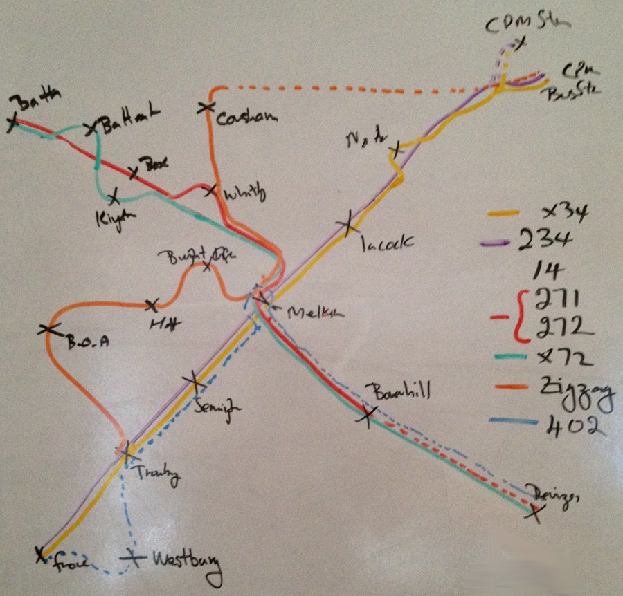 Into professional looking, high res printable, easily editable diagrams. I know we have at least one member who has done fantastic work in this field, and others who may have been involved to some extent too ... and I would really appreciate help in finding something that we can use for our local diagrams (which change on a too-often basis!) |
|
|
|
|
 Logged
|
Coffee Shop Admin, Acting Chair of Melksham Rail User Group, Option 24/7 Melksham Rep
|
|
|
|
Rhydgaled
|
|
« Reply #1 on: March 17, 2013, 00:25:44 » |
|
I'm glad you asked this question, as I'm looking for a similar sort of thing myself.
I've produced a few transport maps using Adobe Illustrator (which can open .pdf files, in my case a ValleyLines network map and the London Tube Map and edit them). However, while this tactic is great with simple diagrams of a network, getting different lines that follow the same route to be perfectly parallel is very difficult and time consuming.
I'm often trying to explain various plans/ideas/proposals of mine for various transport networks, the problem is that with Illustrator it takes me far too long to produce nice maps, and a picture is worth a thousand words (ok, maybe not that many) so I fear my letters/posts could be too long for the recipents to read. Even if they read my speels, they don't often appear to understand my proposals.
I had just decided to start trying to learn how to use the C#.NET Systems.Drawing graphics library (<- programming talk, I'm a software engineering student) to write my own software to draw lines that snap nicely next to each other. But that also will be VERY time consuming so if anybody can recomend a tool to save me that work that'd be great
|
|
|
|
« Last Edit: March 17, 2013, 10:06:25 by Rhydgaled »
|
Logged
|
----------------------------
Don't DOO▸ it, keep the guard (but it probably wouldn't be a bad idea if the driver unlocked the doors on arrival at calling points).
|
|
|
Scott
Full Member

Posts: 76
First S&A Expert

|
|
« Reply #2 on: March 17, 2013, 02:09:17 » |
|
Sometimes all it needs is a basic image-editing programme such as MS Paint or GIMP. However, to get this plan to work effectively can take quite literally hours - the above diagram could take anything up to 2^ hours to make, and this obviously isn't ideal. Alternatively, with some careful pixel manipulation you can achieve such diagrams using MS Office at a much faster speed, but again it takes a precision that may just not be possible owing to timeframe.
I could definitely make the above map on an older form of Paint - i.e. before the HD graphics rendered edges blurred instead of solid when using the brush - in about 30 or so minutes, but that isn't for everyone...
|
|
|
|
|
Logged
|
Click here for advice on bus travel or here for bus terminology. N.B.: I am not (yet) an official employee of First Group. |
|
|
|
eightf48544
|
|
« Reply #3 on: March 17, 2013, 14:36:05 » |
|
Just a thought. Might it be easier to produce a paper master copy which can be scanned or photographed and then manipulated in something like Paint? Drawing curvy lines in digital (pixals) is tricky. You could contact Trackmaps who are just down the road from you. Little Court Upper South Wraxall Bradford-on-Avon BA15 2SE Tel: 0845 300 1370 Fax: 0845 300 1375 E.Mail: sales@trackmaps.co.uk |
|
|
|
|
Logged
|
|
|
|
|
ellendune
|
|
« Reply #4 on: March 17, 2013, 15:13:13 » |
|
Drawing curvy lines in digital (pixels) is tricky.
Not if you use the right sort of program. There are two sorts of graphics package. Raster and Vector. Raster programs essentially deal in pixels. They might have tools that allow you to draw lines but essentially they just put down pixels that are then difficult to move. Vector programs deal in lines and store that information as lines. The drawing facility in MSWord is vector, but does not have many tools to tidy up your picture, but I would suggest you try that first. I have done a similar drawing by importing a scanned image of what I wanted and tracing over it in lines before deleting my scanned image. You may be able to do a bit better in MS Visio, but I have never tried. The ultimate Vector graphics program is of course a Computer Aided Design (CAD) package. They tend to take a bit of time to get the hang of, but really would do the job. However, you would only be using a small part of the capability and so they would be very expensive. If I was doing it I would use Turbo CAD, but then I already have the software (for other reasons that require more of the capability) and the experience. I have never used illustrator, but I expect it should do the Job very well - it may be just a case of getting to know the software. |
|
|
|
|
Logged
|
|
|
|
|
devon_metro
|
|
« Reply #5 on: March 17, 2013, 16:35:51 » |
|
I've had experience using CorelDraw and can't imagine it would be particularly difficult to do what you require.
|
|
|
|
|
Logged
|
|
|
|
|
IndustryInsider
|
|
« Reply #6 on: March 17, 2013, 16:56:57 » |
|
Did anyone see the recent episode of 'Map Man' with Nicholas Crane that concentrated on Harry Beck's London Underground map. Sadly, I think it's disappeared off of the iPlayer now. As well as being an interesting documentary they showed the software used to alter the current LU map, in which Crane invented a new tube line. Not sure what software package they used - but it looked perfect for your needs, Graham!
|
|
|
|
|
Logged
|
To view my GWML▸ Electrification cab video 'before and after' video comparison, as well as other videos of the new layout at Reading and 'before and after' comparisons of the Cotswold Line Redoubling scheme, see: http://www.dailymotion.com/user/IndustryInsider/ |
|
|
|
Phil
|
|
« Reply #7 on: March 17, 2013, 17:03:17 » |
|
I had some success creating a quick public rights of way map for the town I live in using open source OSM http://www.openstreetmap.org/ plus a combination of layers and vectored lines using Illustrator. |
|
|
|
|
Logged
|
|
|
|
|
TerminalJunkie
|
|
« Reply #8 on: March 17, 2013, 17:58:20 » |
|
Did anyone see the recent episode of 'Map Man'
It's not that recent: it was first broadcast in 2004! |
|
|
|
|
Logged
|
Daily Mail and Daily Express readers please click here. |
|
|
|
|
|
IndustryInsider
|
|
« Reply #10 on: March 17, 2013, 18:56:32 » |
|
Did anyone see the recent episode of 'Map Man'
It's not that recent: it was first broadcast in 2004! Was it? Oops.  I came across it on iPlayer a couple of months ago, so assumed it was a recent programme. Still, in comparison to the dates of some of the maps he bases his programmes on, 2004 is quite recent I suppose! |
|
|
|
|
Logged
|
To view my GWML▸ Electrification cab video 'before and after' video comparison, as well as other videos of the new layout at Reading and 'before and after' comparisons of the Cotswold Line Redoubling scheme, see: http://www.dailymotion.com/user/IndustryInsider/ |
|
|
|
LiskeardRich
|
|
« Reply #11 on: March 17, 2013, 19:01:58 » |
|
Graham, I havent the time unfortunately, but have just used ms paint and near enough quick copied 3-4 of your routes, which have come out ok. With a little time and patience (and a steady hand to get the curved lines right, something I dont have), such a diagram could be created fairly easily on ms paint. Assuming your requirement for mac would have a similar software.
|
|
|
|
|
Logged
|
All posts are my own personal believes, opinions and understandings!
|
|
|
|
Trowres
|
|
« Reply #12 on: March 17, 2013, 22:32:28 » |
|
I've just spent a few minutes playing with Openoffice Draw. It is possible to use "connectors" with some custom-drawn symbols to produce lines that connect "station blobs" on a diagram. The connectors come in several styles (straight, curved, dogleg etc). However, while it is possible (by defining extra "glue points" on symbols) to join two stations with more than one line (like District & Circle on LU), some manual editing is needed with some connector styles as they don't come out neatly parallel.
Overall review - usable but some up-front effort needed to create station symbols with glue points in the right places.
(I used a Windows version - presuming there is a Mac equivalent).
|
|
|
|
|
Logged
|
|
|
|
|
grahame
|
|
« Reply #13 on: March 18, 2013, 07:50:09 » |
|
Lots of ideas, thanks. I'm not sure which / whether any of them is going to work best. I'm looking for truly High Res which (I think) means I should look only at Vector Graphics - the resultant diagrams may get printed out quite large. And as I go from route data to position data, then from position data to pixel data, amending becomes so much harder. I wonder what TfL» use for their bus route maps at stops.
The illustration at the top of the page took about 5 minutes on the whiteboard ... and I would love to find something that takes less than an hour to put onto a system - then is easily modified to add in extra links such as that Bath to Bristol Airport connection that starts next weekend, and so on. Then come July we may see a shakeup. Ironically, I spent much of the 1980s designing and writing exactly the software I want - kept me employed for the best part of a decade - but I don't think I've still got the old Fortran and C source. I'm thinking of scripting an SVG generator ... but that's probably madness, and will probably have to remain as a thought until I give up a lot of other things or retire - by which time the technology will have moved on again anyway!
|
|
|
|
|
Logged
|
Coffee Shop Admin, Acting Chair of Melksham Rail User Group, Option 24/7 Melksham Rep
|
|
|
Scott
Full Member
Posts: 76
First S&A Expert
|
|
« Reply #14 on: March 18, 2013, 15:47:52 » |
|
Further to what Rich said, if a Paint equivalent does exist I'd be happy to do it for you. I would also include all manner of things like corners and colours in a separate file which you could then copy for one to the other without the need to create them all by hand every time. It would just be a case of getting the pixels to line up.
My profile picture was made in this manner - but it is rather more complex than your diagram (which inspired the idea, so thank you)!
In fact, seeing as I have nothing else to do, I might go and do just that. If you want the end result let me know and I'll e-mail it to you.
By the way, what is the 402? It's not a route I (or Traveline apparently) recognise...?
|
|
|
|
« Last Edit: March 18, 2013, 16:09:50 by Scott »
|
Logged
|
Click here for advice on bus travel or here for bus terminology. N.B.: I am not (yet) an official employee of First Group. |
|
|
|