|
grahame
|
 |
« Reply #60 on: December 05, 2012, 16:09:41 » |
|
Both that route and the GWR▸ converge at Cowley and to my mind, it is the Exe valley that is the headache.
To relieve the "single point of failure" problem / getting trains to Plymouth, you could: 1. Complete the triangle from Exeter Central to St Thomas (a line that passes under St David's Hill / Iron Bridge, over Bonhay Road near the weirs, over the flood channel and down to join the current line where it crossed Okehampton Road / Okehampton Street. 2. Reopen from Okehampton to Tavistock / Bere Alston. You then have two independent routes from London to Plymouth .. (a) Waterloo, Central, St. Thomas, Totnes, Plymouth and (b) Paddington, St. Davids (reverse) and Meldon to Plymouth. Which is better that it every was in the past - as far as I can tell, the only way ever to avoid Cowley Bridge was from London via Taunton, Barnstaple Town, Barnstaple Junction, Meeth and Halwill! |
|
|
|
|
 Logged
|
Coffee Shop Admin, Acting Chair of Melksham Rail User Group, Option 24/7 Melksham Rep
|
|
|
|
TerminalJunkie
|
|
« Reply #61 on: December 05, 2012, 16:43:13 » |
|
[...] via Taunton, Barnstaple Town, Barnstaple Junction, Meeth [...]
ITYM Barnstaple Victoria Road, not Barnstaple Town. |
|
|
|
|
Logged
|
Daily Mail and Daily Express readers please click here. |
|
|
|
grahame
|
|
« Reply #62 on: December 05, 2012, 16:58:43 » |
|
[...] via Taunton, Barnstaple Town, Barnstaple Junction, Meeth [...]
ITYM Barnstaple Victoria Road, not Barnstaple Town. I think I do. Thanks! |
|
|
|
|
Logged
|
Coffee Shop Admin, Acting Chair of Melksham Rail User Group, Option 24/7 Melksham Rep
|
|
|
|
swrural
|
|
« Reply #63 on: December 05, 2012, 17:38:51 » |
|
The area around Norton F was well under water recently (Tone Valley). The sea is one thing, the rivers are another. Long term, we need stilts. Seriously, the report, (Stern I think) did point all this out. Taking Graham's points, I believe a flyover at Cowley Jcn allowing SR‡ diversions to avoid the flooding there is feasible (not sure what to do about the GW▸ to Tiverton though). Thus the diversion route via Honiton and then pressing on through Okehampton seems a goer, likewise his chord to St Thomas, if the sea is OK but the river not. My impression is that re-dualling Exeter to Castle Cary via Yeovil Jcn has become a strategic no-brainer. I do point out that the Axe Valley is a huge problem too, for the same reason as that the Culm and Exe valleys are. My problem with the franchise set up is that Strategy is not within their remit, is it? ('Priced Options' - what on earth is that all about strategically?). As far as NR» is concerned, 'Business Case'  , we are talking strategy for survival here, not business cases.  |
|
|
|
|
Logged
|
|
|
|
|
Southernman
|
|
« Reply #64 on: December 05, 2012, 23:33:12 » |
|
Not entirely sure why people have such hang-ups regarding reversals. The use of units (of one sort or another) is standard fare and the extra time taken in reversing a train is not great. Excursions, Sleeper trains and Freight are obvious exceptions. Exeter St Davids has interchange facilities whereas Central would require significant upgrading if the former station was to be omitted in a regular calling pattern.
The Axe Valley itself does flood but in the past has tended not to disrupt the railway often. Hopefully the recent works around Broom Crossing will prevent a repeat of the washouts. There have been plenty of landslips however.
Maybe the railway around Cowley Bridge will have to be raised above/around the flood plain if repeated problems occur! And yes, reopen via Okehampton as it is only a matter of time before the seawall is blocked big time.
|
|
|
|
|
Logged
|
|
|
|
|
grahame
|
|
« Reply #65 on: December 06, 2012, 06:24:37 » |
|
Not entirely sure why people have such hang-ups regarding reversals. If you're looking at my "chord" suggestion, that was to remove a single point of failure (St David's Station) rather than to remove a reversal I agree that - interchange wise - it's sensible to have a single station. Just look at how man cross-London transfers would be avoided if lines into Paddington, Euston, St Pancras, King's Cross, Liverpool Street, Charing Cross, Victoria and Waterloo had all been extended into Holborn Kingsway, renamed "London Central". |
|
|
|
|
Logged
|
Coffee Shop Admin, Acting Chair of Melksham Rail User Group, Option 24/7 Melksham Rep
|
|
|
|
Bob_Blakey
|
|
« Reply #66 on: December 06, 2012, 07:20:42 » |
|
The railway at Cowley Bridge Junction (CBJ) is already above flood plain level. During the recent deluge the line between CBJ and Stoke Canon (SC) remained above water at all times. I personally believe that the problem is caused by a combination of factors: The A377 embankment which traverses the Exe / Creedy flood plain at this point restricts drainage. The railway line between SC & CBJ crosses the flood plain from north to south and during flooding forces water to the south of the line because of the lack of culverts/bridges-when the water reaches CBJ it has nowhere else to go but over the line because the spillway under the railway is not big enough. This can be permanently sorted out but do the powers-that-be want to spend 'loadsofmoney' on an event that is seriously disruptive but very rare?
|
|
|
|
|
Logged
|
|
|
|
|
Tim
|
|
« Reply #67 on: December 06, 2012, 09:41:40 » |
|
AIUI▸ it is the cliff behind that is crumbling all the time and not the sea wall. I believe that is why NR» is sanguine (no, better than that, technically confident) that the sea wall route is capable of maintenance.
I hadn't appreciated that, thanks. Your quote has of course been supported by the recent landslips. |
|
|
|
|
Logged
|
|
|
|
|
woody
|
|
« Reply #68 on: December 07, 2012, 09:38:37 » |
|
Regarding the recent landslips at Teignmouth,I noticed yesterday as I passed on the up line at 20mph that their seems to be a great deal of muddy water still coming out of the cliff face where the main landslip occured.Indeed the entire track bed ballast is still waterlogged/partly submerged at that point as a result of the still large volumes of red muddy water running out of the cliff face which can be clearly seen finding it way into the sea at high tide from underneath the sea wall/track formation.It looks to me as if a spring has been opened in the cliff face following the landslips as most of the rest of the cliff face is largely dry now.As a result the whole cliff face as that point looks very waterlogged and unstable despite the removal of 1500 tons of material and I am therefore somewhat surprised that trains are being allowed to run by at this point.
I would welcome some professional input on this one because to my amateur eye it genuinely still looks very dodgy there for trains to pass by.
|
|
|
|
|
Logged
|
|
|
|
|
swrural
|
|
« Reply #69 on: December 07, 2012, 10:54:01 » |
|
I haven't got professional info I am afraid, but perhaps personal knowledge may be helpful. I live further along the coast where the landslips are very prevalent, namely the blue lias cliffs from Seaton to Bridport Harbour.
What happens is that the current heavy rain saturates the ground. Then we get real winter in Jan /Feb that freezes the water within the natural fissures of the rock. When spring arrives, the water expands and then a landslide results. This of course is aided by the fact that there are cliffs. If the land ceases to be a cliff and settles to a gentle slope, then the process continues, but with much less effect and you get (what we indeed see inland) a succession of 'folds' that over the centuries constantly constantly alter the shape of the land.
Golden Cap near Bridport is the highest cliff in England but it won't be forever. It'll all go one day.
I imagine the sandstone cliffs at Dawlish are as vulnerable as the above description but it's more of a 'crumble' than the 'mudslides' we get further along.
I am sure a geologist could have done better but I hope this helps.
|
|
|
|
|
Logged
|
|
|
|
|
TerminalJunkie
|
|
« Reply #70 on: December 07, 2012, 11:03:33 » |
|
Golden Cap near Bridport is the highest cliff in England [...]
Er, no it isn't - it's only 191m at the summit. The cliff face at Great Hangman is 244m. |
|
|
|
|
Logged
|
Daily Mail and Daily Express readers please click here. |
|
|
|
devon_metro
|
|
« Reply #71 on: December 07, 2012, 12:05:07 » |
|
Sandstone is a porous rock so will naturally be more unstable when saturated with water.
swrural you refer to a process known as 'freeze-thaw weathering' where rocks are weakened when ice expands in cracks/joints. You find this in harder rocks e.g. the granite tors on Dartmoor, i suspect the landslides along the seawall are merely as a results of the softer sandstone failing where water is at higher concentrations as the individual sand grains are less consolidated.
|
|
|
|
|
Logged
|
|
|
|
|
macbrains
|
|
« Reply #72 on: December 07, 2012, 13:42:06 » |
|
Golden Cap near Bridport is the highest cliff in England [...]
Er, no it isn't - it's only 191m at the summit. The cliff face at Great Hangman is 244m. I suspect swrural may have meant that Golden Cap is the highest point on the south coast rgds macbrains |
|
|
|
|
Logged
|
|
|
|
|
swrural
|
|
« Reply #73 on: December 07, 2012, 13:48:32 » |
|
Yes I did - I'm sorry, it was sloppy.
|
|
|
|
|
Logged
|
|
|
|
|
bobm
|
|
« Reply #74 on: March 31, 2013, 14:03:28 » |
|
The seawall has taken a battering over the last few days with strong winds coupled with high tides. However I am not aware of any major disruption although there are quite a few 143s running round with salt caked windows on one side. This was the scene near Teignmouth at 11am on Easter Day. 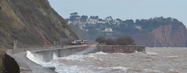 |
|
|
|
|
Logged
|
|
|
|
|